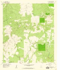
1959 Map of Bear Hollow
USGS Topo · Published 1960About this map
Cherokee Creek and its southern tributaries define the topography of this San Saba County landscape in the late 1950s. The map captures a rural ranching economy reliant on carefully managed water sources, evidenced by dozens of named catchments such as Rattlesnake Pond, Red Tank, and the Bear Hollow Windmill. The presence of the Montgomery Cem and family-named landmarks like Blackjack Hill and Horse Mtn provide essential reference points for genealogists tracing ancestral land tracts in the region.
Find a feature on this map
44 named features on this map. Tap any name to fly to it.
Don’t see what you’re looking for? This feature index may not catch every label — zoom into the map to look around manually.
Map Details
Editions of this 1959 Bear Hollow Map
This is the sole edition of this map. No revisions or reprints were ever made.
Other maps of this area

1885 · San Saba
USGS Topo · 1:125,000

1887 · Llano
USGS Topo · 1:125,000

1894 · San Saba
USGS Topo · 1:125,000

1894 · Llano
USGS Topo · 1:125,000

1904 · Llano
USGS Topo · 1:125,000

1909 · Llano
USGS Topo · 1:125,000

1918 · Llano
USGS Topo · 1:125,000

1925 · San Saba 4-a
USGS Topo · 1:48,000

1931 · Bend
USGS Topo · 1:62,500

1954 · Brownwood
USGS Topo · 1:250,000