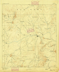
1887 Map of Llano
USGS Topo · Published 1887About this map
Llano River serves as the central artery of this Central Texas landscape, as it appeared shortly after the Llano townsite was established as the county seat. This 1885 survey reveals a terrain defined by isolated granite massifs and sprawling creek systems, including Six Mile Creek and Hickory Creek. The distribution of small settlements like Valley Spring, Castell, and Pontotoc suggests a nascent rural economy of ranching and early mining, with prominent landmarks such as Enchanted Rock and Smoothingiron Mountain anchoring the topography. To the east, the rugged contours of Pack Saddle Mountain and Sharp Mountain overlook early hamlets like Lone Grove. This record captures the transition from a frontier territory into a organized agricultural district, preserving the locations of early post offices and community centers before the arrival of major rail infrastructure or modern road networks changed the character of the Hill Country.
Find a feature on this map
88 named features on this map. Tap any name to fly to it.
Don’t see what you’re looking for? This feature index may not catch every label — zoom into the map to look around manually.
Map Details
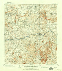
Editions of this 1887 Llano Map
This is the sole edition of this map. No revisions or reprints were ever made.
Historical Maps of Llano Through Time
10 maps found