1960s Maps of Smith County, Texas
Explore 13 historic maps of Smith County from the 1960s. These maps offer a rare glimpse into what life looked like during the 1960s — showing old roads, neighborhoods, homes, and landmarks that have changed or disappeared over time.
Whether you're researching your family's past, planning a metal detecting trip, or studying how Smith County's landscape evolved across the 1960s, these high-resolution maps are a powerful tool for exploring the history of this region.
- Focus on a specific era: All maps on this page are from the 1960s, giving you a focused view of this time period.
- See what’s changed: Compare century-old streets, trails, and buildings to today's modern landscape using overlays and satellite layers.
- Research with precision: Use these maps for genealogy, historical research, land use analysis, or educational projects.
- View, download, or print: Maps are fully viewable online in high resolution, and can be downloaded or printed for your own records.
Start exploring Smith County's history through authentic maps from the 1960s. This is your window into the past.
Smith County, TX maps
(13)- 1960 Map of Hawkins, 1961 Print
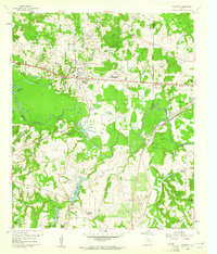 1960 Hawkins1961 Print · USGSHawkins and the Sabine River valley are shown here during the peak of the local oil boom in the early sixties. Researchers can trace family sites near Jarvis Christian College, find old burials at Liberty Cem, or locate the Hawkins Oil Field wells.3 unique versions available
 - 1960 Map of Big Sandy, 1961 Print
 1960 Big Sandy1961 Print · USGSIn the early 1960s, this East Texas corridor was defined by the confluence of major rail lines and the Sabine River. Genealogists can trace family names and rural communities through Union Grove Ch, Chilton Cem, and the old settlement at Waters Bluff.3 unique versions available
 - 1960 Map of Lindale, 1962 Print
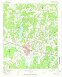
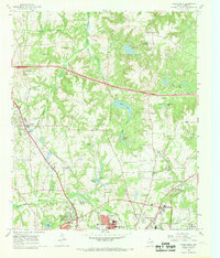
 1960 Lindale1962 Print · USGSLindale and its East Texas surroundings are captured here at a moment of mid-century growth along the Missouri Pacific rail line. Genealogists and local historians can trace family roots through sites like Flewellen Cem, the Bragg Morris High Sch, and the community at Friendship.3 unique versions available
 - 1960 Map of Crow, 1962 Print
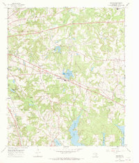
 1960 Crow1962 Print · USGSWood and Smith Counties are captured here in the early sixties, defined by the winding Sabine River and the rural community of Red Springs. Researchers can locate Red Springs Cem, family-named water bodies like Overton Lake, and several country churches.2 unique versions available
 - 1960 Map of Gladewater, 1962 Print
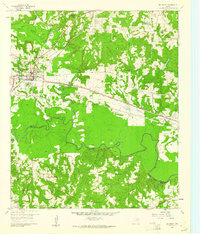
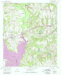
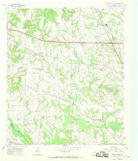
 1960 Gladewater1962 Print · USGSEast Texas at the start of the 1960s reveals a landscape of oil production and rural communities centered on the Sabine River. Researchers can trace the Texas and Pacific rail line through Gladewater and locate local landmarks like the Edwards Cem and Warren City.2 unique versions available
 - 1966 Map of Chandler, 1967 Print
 1966 Chandler1967 Print · USGSChandler and the surrounding East Texas countryside are shown in the mid-sixties during the development of Lake Palestine. Researchers can trace old family roots at Macedonia Cem and Sevenleague Cem or locate former community centers like Dixie Sch.3 unique versions available
 - 1966 Map of Hope Pond, 1968 Print
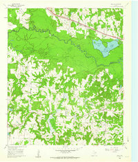
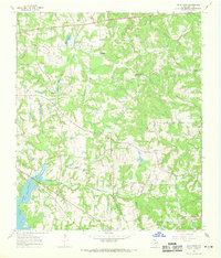 1966 Hope Pond1968 Print · USGSEast of Tyler in the mid-1960s, this area of Smith County shows a rural landscape of winding creeks and family cemeteries. Genealogists can locate legacy sites like Holt Cem and Wilson Curtis Cem or trace the path of the Missouri Pacific railroad.3 unique versions available
 - 1966 Map of Starrville, 1969 Print
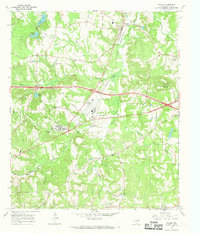
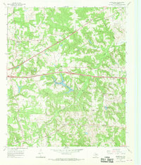 1966 Starrville1969 Print · USGSNortheast Smith County is shown here in the mid-1960s as a landscape defined by rural communities and a growing petroleum industry. Local historians can trace family roots at Pinkston Cem and Siloam Cem, or locate the refineries and wells of the Chapel Hill Oil Field.2 unique versions available
 - 1966 Map of Tyler North, 1969 Print
 1966 Tyler North1969 Print · USGSThe northern environs of Tyler during the mid-1960s show a mix of rural oil production and suburban expansion. Genealogists can locate family landmarks like Shamburger Cem or Old Butler Cem and trace the paths of the Missouri Pacific and St Louis Southwestern railroads.2 unique versions available
 - 1966 Map of Mount Sylvan, 1969 Print
 1966 Mount Sylvan1969 Print · USGSThe rural communities of Smith County are frozen in the mid-sixties, showing a landscape of oil wells, creek-fed farms, and country churches. Genealogists can trace family landmarks like Sitton Cem, Dixie Sch, and the settlements of Mount Sylvan and New Harmony.2 unique versions available
 - 1966 Map of Bascom, 1969 Print
 1966 Bascom1969 Print · USGSSmith County is shown here in the late sixties as the region's water and oil infrastructure matured southeast of Tyler. Family historians can trace rural roots through Emmanuel Cem, Bascom Ch, and the grounds of the Texas State Quail Farm.3 unique versions available
 - 1966 Map of Winona, 1969 Print
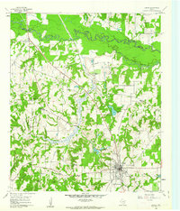
 1966 Winona1969 Print · USGSMid-century Smith County is captured during a period of institutional growth along the St Louis Southwestern rail line. Genealogists can trace family names at McDougle Cem, Ingram Cem, and the East Texas Tuberculosis Hospital.2 unique versions available
 - 1966 Map of Tyler South, 1970 Print
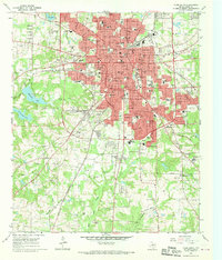 1966 Tyler South1970 Print · USGSTyler was experiencing a surge of post-war growth in the sixties, visible here through its expanding neighborhoods and civic institutions. Genealogists and local historians can trace family plots across a high concentration of cemeteries including Oakwood Cem and St Louis Cem, or locate landmarks like Caldwell Zoo and Tyler Jr College.3 unique versions available
End of results
Showing maps 1-13 of 13
Top cities of Smith County
- Tyler historical maps
- Whitehouse historical maps
- Lindale historical maps
- Hideaway historical maps
- Troup historical maps
- Arp historical maps
See more
Frequently asked questions
- What are the different types of historical maps available for Smith County?
- What is the oldest map of Smith County?
- Where can I purchase historical maps of Smith County for my home or office?
- Where can I download high-res historical maps of Smith County?
- Are there historical topographic maps available for Smith County?
- Is there historical aerial imagery available for Smith County?
- Where are historical maps of Smith County sourced from?