1970s Maps of Troup, Texas
Explore 2 historic maps of Troup from the 1970s. These maps offer a rare glimpse into what life looked like during the 1970s — showing old roads, neighborhoods, homes, and landmarks that have changed or disappeared over time.
Whether you're researching your family's past, planning a metal detecting trip, or studying how Troup's landscape evolved across the 1970s, these high-resolution maps are a powerful tool for exploring the history of this region.
- Focus on a specific era: All maps on this page are from the 1970s, giving you a focused view of this time period.
- See what’s changed: Compare century-old streets, trails, and buildings to today's modern landscape using overlays and satellite layers.
- Research with precision: Use these maps for genealogy, historical research, land use analysis, or educational projects.
- View, download, or print: Maps are fully viewable online in high resolution, and can be downloaded or printed for your own records.
Start exploring Troup's history through authentic maps from the 1970s. This is your window into the past.
Troup, TX maps
(2)- 1973 Map of Troup West, 1976 Print
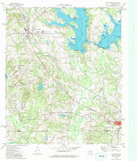 1973 Troup West1976 Print · USGSSettlements in eastern Smith County flourished along the rail lines and reservoir shores during the early 1970s. Genealogists and local historians can locate several family landmarks and community centers, including Memorial Cem, Walnut Grove Ch, and the Troup townsite.2 unique versions available
 - 1973 Map of Troup East, 1976 Print
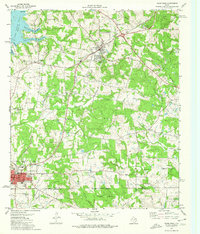 1973 Troup East1976 Print · USGSEast Texas in the early seventies was a landscape where petroleum production met quiet rural life. Genealogists and historians can trace the family landmarks of Sinclair City and Arp alongside numerous sites like Shiloh Cem and Mason Ch.
End of results
Showing maps 1-2 of 2
Top cities near Troup
- Tyler historical maps
- Jacksonville historical maps
- Kilgore historical maps
- Whitehouse historical maps
- Bullard historical maps
- Overton historical maps
See more
Frequently asked questions
- What are the different types of historical maps available for Troup?
- What is the oldest map of Troup?
- Where can I purchase historical maps of Troup for my home or office?
- Where can I download high-res historical maps of Troup?
- Are there historical topographic maps available for Troup?
- Is there historical aerial imagery available for Troup?
- Where are historical maps of Troup sourced from?