1960s Maps of Georges Creek, Texas
Explore 1 historic maps of Georges Creek from the 1960s. These maps offer a rare glimpse into what life looked like during the 1960s — showing old roads, neighborhoods, homes, and landmarks that have changed or disappeared over time.
Whether you're researching your family's past, planning a metal detecting trip, or studying how Georges Creek's landscape evolved across the 1960s, these high-resolution maps are a powerful tool for exploring the history of this region.
- Focus on a specific era: All maps on this page are from the 1960s, giving you a focused view of this time period.
- See what’s changed: Compare century-old streets, trails, and buildings to today's modern landscape using overlays and satellite layers.
- Research with precision: Use these maps for genealogy, historical research, land use analysis, or educational projects.
- View, download, or print: Maps are fully viewable online in high resolution, and can be downloaded or printed for your own records.
Start exploring Georges Creek's history through authentic maps from the 1960s. This is your window into the past.
Georges Creek, TX maps
(1)- 1961 Map of Nemo, 1963 Print
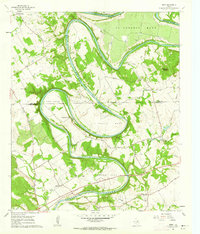 1961 Nemo1963 Print · USGSThe Brazos River winds through the Hood and Somervell County border in the early sixties, creating a landscape of deep river bends and small rural communities. Genealogists can trace family roots at Mitchell Bend Cem or Oldham Cem, and locate landmarks like Fort Spunkey and Mambrino.3 unique versions available
End of results
Showing maps 1-1 of 1
Top cities near Georges Creek
- Burleson historical maps
- Cleburne historical maps
- Joshua historical maps
- Granbury historical maps
- Glen Rose historical maps
- Godley historical maps
Frequently asked questions
- What are the different types of historical maps available for Georges Creek?
- What is the oldest map of Georges Creek?
- Where can I purchase historical maps of Georges Creek for my home or office?
- Where can I download high-res historical maps of Georges Creek?
- Are there historical topographic maps available for Georges Creek?
- Is there historical aerial imagery available for Georges Creek?
- Where are historical maps of Georges Creek sourced from?