1900s (20th Century) Maps of Breckenridge, Texas
Explore 5 historic maps of Breckenridge from the 1900s (20th Century). These maps offer a rare glimpse into what life looked like during the 1900s — showing old roads, neighborhoods, homes, and landmarks that have changed or disappeared over time.
Whether you're researching your family's past, planning a metal detecting trip, or studying how Breckenridge's landscape evolved across the 1900s, these high-resolution maps are a powerful tool for exploring the history of this region.
- Focus on a specific era: All maps on this page are from the 1900s, giving you a focused view of this time period.
- See what’s changed: Compare century-old streets, trails, and buildings to today's modern landscape using overlays and satellite layers.
- Research with precision: Use these maps for genealogy, historical research, land use analysis, or educational projects.
- View, download, or print: Maps are fully viewable online in high resolution, and can be downloaded or printed for your own records.
Start exploring Breckenridge's history through authentic maps from the 1900s. This is your window into the past.
Breckenridge, TX maps
(5)- 1954 Map of Abilene, 1966 Print
 1954 Abilene1966 Print · USGSThe Texas Big Country comes into focus in the mid-1950s as petroleum and new water projects reshape the landscape. Local historians can trace the Butterfield Trail, find the Fort Phantom Hill Ruins, and locate numerous small communities along the Texas & Pacific line.2 unique versions available
 - 1958 Map of Abilene
 1958 Abilene1958 Print · USGSMid-century West Texas comes alive in this survey of the Abilene and Stephenville region during a period of steady oil expansion and military growth. Genealogists and local historians can trace the paths of the Texas & Pacific RR through historic towns, locate the Fort Griffin Ruins, and find smaller settlements like Desdemona and Lueders.
 - 1958 Map of Breckenridge, 1959 Print
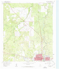 1958 Breckenridge1959 Print · USGSBreckenridge and its surrounding oil-and-cattle country are documented here during the late fifties. Genealogists and local historians can trace the Rock Island Railroad, locate the Picketville Cem, and identify numerous Sludge Pits from the era's energy production.3 unique versions available
 - 1961 Map of Buck Mountain, 1962 Print
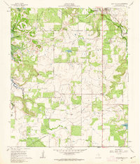 1961 Buck Mountain1962 Print · USGSStephens County appears here in the early sixties during the construction of Hubbard Creek Lake. Genealogists and historians can trace the original landscape before flooding, locating Post Oak Cem, the Curry Oil Field, and the Chicago Rock Island and Pacific rail line.3 unique versions available
 - 1985 Map of Mineral Wells
 1985 Mineral Wells1985 Print · USGSNorth-central Texas in the mid-eighties shows a landscape of deep river valleys and massive reservoirs. Genealogists and historians can trace the Missouri Pacific rail line and locate rural settlements like Thurber, Necessity, and Palo Pinto.2 unique versions available
End of results
Showing maps 1-5 of 5
Frequently asked questions
- What are the different types of historical maps available for Breckenridge?
- What is the oldest map of Breckenridge?
- Where can I purchase historical maps of Breckenridge for my home or office?
- Where can I download high-res historical maps of Breckenridge?
- Are there historical topographic maps available for Breckenridge?
- Is there historical aerial imagery available for Breckenridge?
- Where are historical maps of Breckenridge sourced from?