1890s Maps of Sutton County, Texas
Explore 2 historic maps of Sutton County from the 1890s. These maps offer a rare glimpse into what life looked like during the 1890s — showing old roads, neighborhoods, homes, and landmarks that have changed or disappeared over time.
Whether you're researching your family's past, planning a metal detecting trip, or studying how Sutton County's landscape evolved across the 1890s, these high-resolution maps are a powerful tool for exploring the history of this region.
- Focus on a specific era: All maps on this page are from the 1890s, giving you a focused view of this time period.
- See what’s changed: Compare century-old streets, trails, and buildings to today's modern landscape using overlays and satellite layers.
- Research with precision: Use these maps for genealogy, historical research, land use analysis, or educational projects.
- View, download, or print: Maps are fully viewable online in high resolution, and can be downloaded or printed for your own records.
Start exploring Sutton County's history through authentic maps from the 1890s. This is your window into the past.
Sutton County, TX maps
(2)- 1893 Map of Rock Springs
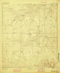 1893 Rock Springs1893 Print · USGSThe Edwards Plateau in the early 1890s was a remote ranching frontier defined by isolated outposts and limestone river breaks. Researchers can locate early family holdings such as Marsh & Taylor's Ranch and landmarks like the Devils Sink Hole.5 unique versions available
 - 1893 Map of Fort McKavett
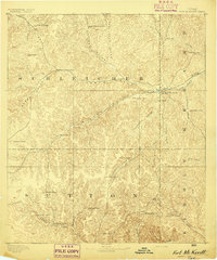 1893 Fort McKavett1893 Print · USGSCentral West Texas ranching life is frozen in time during the 1890s as the frontier era transitions to established livestock spreads. Trace family landholdings and early outposts like Fort McKavett, S.S.S. Ranch, and Henderson Brothers Ranch.4 unique versions available
End of results
Showing maps 1-2 of 2
Top cities of Sutton County
Frequently asked questions
- What are the different types of historical maps available for Sutton County?
- What is the oldest map of Sutton County?
- Where can I purchase historical maps of Sutton County for my home or office?
- Where can I download high-res historical maps of Sutton County?
- Are there historical topographic maps available for Sutton County?
- Is there historical aerial imagery available for Sutton County?
- Where are historical maps of Sutton County sourced from?