1990s Maps of Tarrant County, Texas
Explore 9 historic maps of Tarrant County from the 1990s. These maps offer a rare glimpse into what life looked like during the 1990s — showing old roads, neighborhoods, homes, and landmarks that have changed or disappeared over time.
Whether you're researching your family's past, planning a metal detecting trip, or studying how Tarrant County's landscape evolved across the 1990s, these high-resolution maps are a powerful tool for exploring the history of this region.
- Focus on a specific era: All maps on this page are from the 1990s, giving you a focused view of this time period.
- See what’s changed: Compare century-old streets, trails, and buildings to today's modern landscape using overlays and satellite layers.
- Research with precision: Use these maps for genealogy, historical research, land use analysis, or educational projects.
- View, download, or print: Maps are fully viewable online in high resolution, and can be downloaded or printed for your own records.
Start exploring Tarrant County's history through authentic maps from the 1990s. This is your window into the past.
Tarrant County, TX maps
(9)- 1995 Map of Fort Worth, 2001 Print
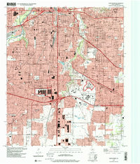 1995 Fort Worth2001 Print · USGSThe southern half of Fort Worth in the mid-nineties shows an established metropolitan landscape of major universities and civic institutions. Genealogists and historians can trace local landmarks like Texas Christian University, the Everman Cem, and the Masonic Home and School.
 - 1995 Map of Benbrook, 2001 Print
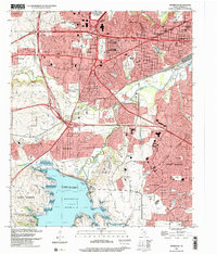 1995 Benbrook2001 Print · USGSWestern Fort Worth and Benbrook appear here in the mid-nineties as the region solidified its role as a major aerospace and rail hub. Researchers can trace the development of White Settlement, the NAS Joint Reserve Base, and local landmarks like Lancaster Yards or Benbrook Lake.
 - 1995 Map of Haltom City, 2001 Print
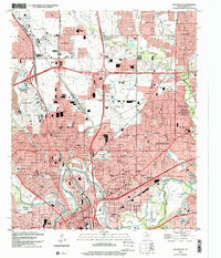 1995 Haltom City2001 Print · USGSThe growing metropolitan sprawl of northeastern Tarrant County is captured here in the mid-nineties. Researchers can trace the development of Haltom City and Saginaw while locating historic sites like Mount Olivet Cemetery and Six Points.
 - 1995 Map of Hurst, 2001 Print
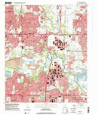
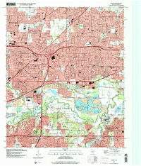 1995 Hurst2001 Print · USGSThe Mid-Cities of Tarrant County show their full suburban expansion in the 1990s as residential neighborhoods fill the gaps between major highways. Genealogists and local historians can locate early family landmarks like Arwine Cem alongside mid-century relics such as the Drive in Theater and Ederville.
 - 1995 Map of Lake Worth, 2001 Print
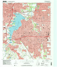
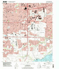
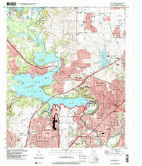 1995 Lake Worth2001 Print · USGSTarrant County's suburban and military landscape is captured here in the mid-1990s as defense industries and lakefront recreation define the area's character. Researchers can trace the layout of Air Force Plant 4, locate the private cemetery, or find early school sites like Castleberry Sch.
 - 1995 Map of Kennedale, 2002 Print
 1995 Kennedale2002 Print · USGSTarrant County at the close of the century shows the rapid growth of the Metroplex around Lake Arlington. Researchers can trace local landmarks like Johnsons Station (BM 558), the Masonic Home, and old family burial grounds at Hawkins Cem.
 - 1995 Map of Arlington, 2002 Print
 1995 Arlington2002 Print · USGSArlington and Grand Prairie appear at a peak of late-century expansion along the Tarrant and Dallas County line. Researchers can trace the growth of Arlington State College or locate family sites at Parkdale Cemetery, St Andrew Church, and Florence Hill.
 - 1995 Map of Britton, 2002 Print
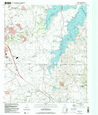 1995 Britton2002 Print · USGSThe Tarrant and Dallas county borderlands were being rapidly transformed by the waters of Joe Pool Lake in the mid-1990s. Local researchers can still find historic landmarks like the Britton settlement, Estes Cem, and Friendship Ch amid the expanding suburbs.
 - 1995 Map of Euless, 2002 Print
 1995 Euless2002 Print · USGSMid-Cities development in the mid-nineties shows the urban interface between the burgeoning Dallas - Fort Worth International Airport and the surrounding suburbs. Researchers can locate long-standing local landmarks like Bear Creek Cem and Mt Elam Ch amid the modern growth of Euless and Irving.
End of results
Showing maps 1-9 of 9
Top cities of Tarrant County
- Fort Worth historical maps
- Arlington historical maps
- North Richland Hills historical maps
- Euless historical maps
- Grapevine historical maps
- Bedford historical maps
See more
Frequently asked questions
- What are the different types of historical maps available for Tarrant County?
- What is the oldest map of Tarrant County?
- Where can I purchase historical maps of Tarrant County for my home or office?
- Where can I download high-res historical maps of Tarrant County?
- Are there historical topographic maps available for Tarrant County?
- Is there historical aerial imagery available for Tarrant County?
- Where are historical maps of Tarrant County sourced from?