1990s Maps of White Settlement, Texas
Explore 2 historic maps of White Settlement from the 1990s. These maps offer a rare glimpse into what life looked like during the 1990s — showing old roads, neighborhoods, homes, and landmarks that have changed or disappeared over time.
Whether you're researching your family's past, planning a metal detecting trip, or studying how White Settlement's landscape evolved across the 1990s, these high-resolution maps are a powerful tool for exploring the history of this region.
- Focus on a specific era: All maps on this page are from the 1990s, giving you a focused view of this time period.
- See what’s changed: Compare century-old streets, trails, and buildings to today's modern landscape using overlays and satellite layers.
- Research with precision: Use these maps for genealogy, historical research, land use analysis, or educational projects.
- View, download, or print: Maps are fully viewable online in high resolution, and can be downloaded or printed for your own records.
Start exploring White Settlement's history through authentic maps from the 1990s. This is your window into the past.
White Settlement, TX maps
(2)- 1995 Map of Benbrook, 2001 Print
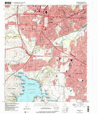 1995 Benbrook2001 Print · USGSWestern Fort Worth and Benbrook appear here in the mid-nineties as the region solidified its role as a major aerospace and rail hub. Researchers can trace the development of White Settlement, the NAS Joint Reserve Base, and local landmarks like Lancaster Yards or Benbrook Lake.
 - 1995 Map of Lake Worth, 2001 Print
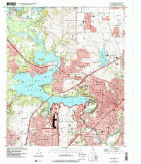 1995 Lake Worth2001 Print · USGSTarrant County's suburban and military landscape is captured here in the mid-1990s as defense industries and lakefront recreation define the area's character. Researchers can trace the layout of Air Force Plant 4, locate the private cemetery, or find early school sites like Castleberry Sch.
End of results
Showing maps 1-2 of 2
Top cities near White Settlement
- Fort Worth historical maps
- Arlington historical maps
- Flower Mound historical maps
- North Richland Hills historical maps
- Keller historical maps
- Haltom City historical maps
See more
Frequently asked questions
- What are the different types of historical maps available for White Settlement?
- What is the oldest map of White Settlement?
- Where can I purchase historical maps of White Settlement for my home or office?
- Where can I download high-res historical maps of White Settlement?
- Are there historical topographic maps available for White Settlement?
- Is there historical aerial imagery available for White Settlement?
- Where are historical maps of White Settlement sourced from?