1920s Maps of Knickerbocker, Texas
Explore 2 historic maps of Knickerbocker from the 1920s. These maps offer a rare glimpse into what life looked like during the 1920s — showing old roads, neighborhoods, homes, and landmarks that have changed or disappeared over time.
Whether you're researching your family's past, planning a metal detecting trip, or studying how Knickerbocker's landscape evolved across the 1920s, these high-resolution maps are a powerful tool for exploring the history of this region.
- Focus on a specific era: All maps on this page are from the 1920s, giving you a focused view of this time period.
- See what’s changed: Compare century-old streets, trails, and buildings to today's modern landscape using overlays and satellite layers.
- Research with precision: Use these maps for genealogy, historical research, land use analysis, or educational projects.
- View, download, or print: Maps are fully viewable online in high resolution, and can be downloaded or printed for your own records.
Start exploring Knickerbocker's history through authentic maps from the 1920s. This is your window into the past.
Knickerbocker, TX maps
(2)- 1924 Map of Sherwood 1-d
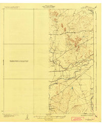
 1924 Sherwood 1-d1924 Print · USGSTom Green County ranching country is captured here in the mid-1920s, showing the early infrastructure of the Concho Valley. You can trace the Kansas City Mexico and Orient rail line through Tankersly or locate the rural crossroads of Knickerbocker.
 - 1928 Map of Tankersly
 1928 Tankersly1928 Print · USGSWest Texas ranching country comes alive in the late 1920s, centered on the strategic river junctions of Tom Green County. Trace the early cattle and rail routes near Knickerbocker, the distinctive Twin Buttes, and the Middle Concho River.3 unique versions available
End of results
Showing maps 1-2 of 2
Top cities near Knickerbocker
Frequently asked questions
- What are the different types of historical maps available for Knickerbocker?
- What is the oldest map of Knickerbocker?
- Where can I purchase historical maps of Knickerbocker for my home or office?
- Where can I download high-res historical maps of Knickerbocker?
- Are there historical topographic maps available for Knickerbocker?
- Is there historical aerial imagery available for Knickerbocker?
- Where are historical maps of Knickerbocker sourced from?