1900s (20th Century) Maps of Lago Vista, Texas
Explore 25 historic maps of Lago Vista from the 1900s (20th Century). These maps offer a rare glimpse into what life looked like during the 1900s — showing old roads, neighborhoods, homes, and landmarks that have changed or disappeared over time.
Whether you're researching your family's past, planning a metal detecting trip, or studying how Lago Vista's landscape evolved across the 1900s, these high-resolution maps are a powerful tool for exploring the history of this region.
- Focus on a specific era: All maps on this page are from the 1900s, giving you a focused view of this time period.
- See what’s changed: Compare century-old streets, trails, and buildings to today's modern landscape using overlays and satellite layers.
- Research with precision: Use these maps for genealogy, historical research, land use analysis, or educational projects.
- View, download, or print: Maps are fully viewable online in high resolution, and can be downloaded or printed for your own records.
Start exploring Lago Vista's history through authentic maps from the 1900s. This is your window into the past.
Lago Vista, TX maps
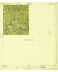
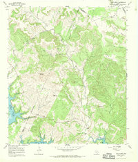
(25)- 1903 Map of Burnet
 1903 Burnet1903 Print · USGSThe Texas Hill Country at the turn of the century shows a landscape of river-side industry and early rail expansion. Trace the historic Houston and Texas Central Railroad line through Burnet and Bertram or locate long-standing landmarks like Morman Mill and Tanyard Crossing.
 - 1909 Map of Burnet
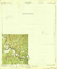
 1909 Burnet1909 Print · USGSThe Texas Hill Country at the turn of the century shows a landscape of river crossings and rail towns before the creation of the Highland Lakes. Genealogists can locate family-named landmarks like Morman Mill, Tumlinson, and rural schoolhouses such as Berry School or Sunny Lane.3 unique versions available
 - 1910 Map of Austin
 1910 Austin1910 Print · USGSAustin and the surrounding Travis County hill country are captured here at the start of the twentieth century. Genealogists and researchers can locate pioneer landmarks like Anderson Mill, Mc.Kinney Falls, and numerous river crossings including Lohmann Ford.3 unique versions available
 - 1930 Map of Austin-2
 1930 Austin-21930 Print · USGSThe winding loops of the Colorado River dominate this 1930 survey of Travis County before the era of major dams. Researchers can trace early crossings like Stewart Ford and locate local landmarks such as the Jack Sch and Ch.
 - 1930 Map of Blanco-1
 1930 Blanco-11930 Print · USGSCentral Texas river valleys appear in high detail during the early 1930s, showing the landscape before later reservoir projects. Trace the original paths of the Colorado River and Pedernales River past Pleasant Grove Sch and Buggy Ford.
 - 1932 Map of Mt. Bonnell
 1932 Mt. Bonnell1932 Print · USGSThe meanders of the Texas Hill Country are captured here in the early 1930s, just before the landscape was transformed by dam construction. You can trace early river life through multiple historical crossings like Lohmann Ford and rural sites like Cox Spring Sch.2 unique versions available
 - 1932 Map of Bertram
 1932 Bertram1932 Print · USGSBurnet County’s river-bound landscape is documented here in the early 1930s, featuring the rural life of Smithwick and the winding COLORADO RIVER. Genealogists can trace family footprints at Pleasant Valley Sch, Hale Ch, and historic river fords like SINGLETON CROSSING.2 unique versions available
 - 1954 Map of Llano, 1964 Print
 1954 Llano1964 Print · USGSThe Texas Hill Country and Highland Lakes appear in the mid-fifties, just as new reservoirs began reshaping the landscape. Trace ranching history and river routes from Mason to Llano, or follow the Gulf Colorado and Santa Fe RR past Buchanan Lake.2 unique versions available
 - 1954 Map of Austin, 1964 Print
 1954 Austin1964 Print · USGSCentral Texas is captured during a period of steady growth as the capital city and its neighboring farm towns began to modernize. Researchers can trace historic rail corridors like the Southern Pacific RR or locate landmarks such as Bergstrom Air Force Base and Pilot Knob.4 unique versions available
 - 1955 Map of Llano
 1955 Llano1955 Print · USGSCentral Texas and the Hill Country are seen here during the mid-1950s growth of the Highland Lakes. Trace old settlements and geologic landmarks from Enchanted Rock and Longhorn Cavern to the small community of Luckenbach.
 - 1956 Map of Llano, 1976 Print
 1956 Llano1976 Print · USGSThe Texas Hill Country comes alive in this mid-seventies survey of the Llano Uplift and Colorado River lakes. Genealogists and historians can trace family roots through settlements like Luckenbach and Castell or locate the famed L B J Ranch and Enchanted Rock.
 - 1959 Map of Lake Travis, 1960 Print
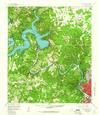 1959 Lake Travis1960 Print · USGSThe Texas Hill Country and the Highland Lakes are captured here during a period of steady growth and ranching. Genealogists can trace early landmarks and family sites like Pond Springs Cem, the Trading Post near Bee Cave, and Schulze Ranch.5 unique versions available
 - 1962 Map of Nameless, 1966 Print
 1962 Nameless1966 Print · USGSThe rural Texas Hill Country comes to life in the 1960s, showing the intersection of Travis and Williamson counties. Genealogists can locate family landmarks like Miller Cem, the small settlement of Nameless, and the sprawling Post Oak Ridge.2 unique versions available
 - 1966 Map of Travis Peak, 1969 Print
 1966 Travis Peak1969 Print · USGSThe Texas Hill Country at the meeting of Travis, Burnet, and Williamson counties is shown here in the mid-1960s. Family historians and researchers can locate Hensel Cem, trace the drainage of Cow Creek, and identify high points like Boultinghouse Mountain.2 unique versions available
 - 1967 Map of Pace Bend, 1969 Print
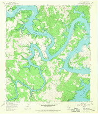 1967 Pace Bend1969 Print · USGSLake Travis and the Colorado River meander through Travis and Burnet Counties in the late sixties as the shoreline began its modern transformation. Genealogists can locate family landmarks like Fall Creek Cem and the traces of Old Ferry Road.2 unique versions available
 - 1968 Map of Mansfield Dam, 1971 Print
 1968 Mansfield Dam1971 Print · USGSThe Travis County hill country is captured here in the late sixties as recreational growth transforms the landscape around Lake Travis. Researchers can trace local heritage at Simpson Cem or explore the development of Jonestown, Volente, and Hudson Bend.3 unique versions available
 - 1985 Map of Austin
 1985 Austin1985 Print · USGSCentral Texas in the mid-eighties reveals a region in transition, balancing rapid urban growth in Austin with deep-rooted rural landscapes. Genealogists and historians can trace family locations near St Johns Ch, the Science Hall schoolhouse, and long-standing communities like Webberville and Manchaca.3 unique versions available
 - 1985 Map of Pedernales River
 1985 Pedernales River1985 Print · USGSThe Texas Hill Country comes alive in the mid-1980s, documenting a landscape of ranching roots and presidential history. Researchers can trace historic settlements like Luckenbach, the presidential grounds of Lyndon B. Johnson National Historic Park, and the early rail path of the Southern Pacific Railroad.2 unique versions available
 - 1985 Map of Llano
 1985 Llano1985 Print · USGSThe Texas Hill Country and Highland Lakes come into focus in the mid-1980s, showcasing the intersection of traditional ranching and modern lakeside growth. Researchers can locate vanished schoolhouses and family burial sites like Valley Spring Sch, Babyhead Cem, and the rural community of Oatmeal.
 - 1985 Map of Taylor, 1986 Print
 1985 Taylor1986 Print · USGSWilliamson and Bell counties in the mid-eighties reveal a landscape where the cattle and cotton economy met burgeoning rail infrastructure. Genealogists and historians can trace the paths of the Missouri Pacific railroad through unique hamlets like Ding Dong, Frame Switch, and Beyersville.2 unique versions available
 - 1986 Map of Travis Peak
 1986 Travis Peak1986 Print · USGSTravis County and Burnet County meet in these rugged Texas hills during the mid-eighties as the reservoir shoreline reshapes the land. Genealogists and hikers can trace remote landmarks like Hensel Cem, Boultinghouse Mountain, and the settlement at Travis Peak.2 unique versions available
 - 1986 Map of Pace Bend
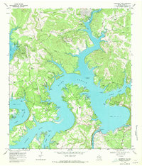
 1986 Pace Bend1986 Print · USGSThe Hill Country terrain of Travis and Burnet counties is captured here in the mid-eighties as the waters of Lake Travis shaped the local economy. Researchers can trace land use through Haynie Flats Cem, the Old Ferry Road, and numerous shoreline landmarks like Muleshoe Bend.2 unique versions available
 - 1986 Map of Mansfield Dam
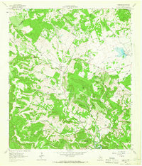
 1986 Mansfield Dam1986 Print · USGSThe Texas Hill Country undergoes a period of significant growth in the mid-eighties as residential developments reach the shores of Lake Travis. Researchers can trace old family burial grounds like Simpson Cem, locate the Mansfield Dam facilities, and explore the early layouts of Lakeway and Lago Vista.
 - 1986 Map of Nameless
 1986 Nameless1986 Print · USGSThe Texas Hill Country north of Lake Travis comes into focus during the mid-eighties, showing a rural landscape of ranch roads and limestone ridges. Genealogists and historians can trace family-named sites like Heinatz Flat, Huddleston Cem, and the uniquely named settlement of Nameless.
 - 1992 Map of Llano
 1992 Llano1992 Print · USGSThe Texas Hill Country comes into focus in the early nineties as the Highland Lakes and the granite uplifts of Llano and Burnet define the landscape. Researchers can trace the Southern Pacific line and locate local landmarks from Enchanted Rock to the Llano County Courthouse.2 unique versions available
End of results
Showing maps 1-25 of 25
Top cities near Lago Vista
- Austin historical maps
- Georgetown historical maps
- Cedar Park historical maps
- Leander historical maps
- Lakeway historical maps
- Liberty Hill historical maps
See more
Frequently asked questions
- What are the different types of historical maps available for Lago Vista?
- What is the oldest map of Lago Vista?
- Where can I purchase historical maps of Lago Vista for my home or office?
- Where can I download high-res historical maps of Lago Vista?
- Are there historical topographic maps available for Lago Vista?
- Is there historical aerial imagery available for Lago Vista?
- Where are historical maps of Lago Vista sourced from?