1980s Maps of Webberville, Texas
Explore 3 historic maps of Webberville from the 1980s. These maps offer a rare glimpse into what life looked like during the 1980s — showing old roads, neighborhoods, homes, and landmarks that have changed or disappeared over time.
Whether you're researching your family's past, planning a metal detecting trip, or studying how Webberville's landscape evolved across the 1980s, these high-resolution maps are a powerful tool for exploring the history of this region.
- Focus on a specific era: All maps on this page are from the 1980s, giving you a focused view of this time period.
- See what’s changed: Compare century-old streets, trails, and buildings to today's modern landscape using overlays and satellite layers.
- Research with precision: Use these maps for genealogy, historical research, land use analysis, or educational projects.
- View, download, or print: Maps are fully viewable online in high resolution, and can be downloaded or printed for your own records.
Start exploring Webberville's history through authentic maps from the 1980s. This is your window into the past.
Webberville, TX maps
(3)- 1982 Map of Utley
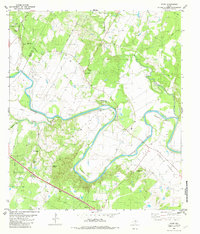 1982 Utley1982 Print · USGSThe Colorado River's dramatic loops define the border between Travis and Bastrop counties during the early eighties. Genealogists can locate numerous family burial sites and rural centers including St Paul Cem, Utley, and Walker-Watson Cem.3 unique versions available
 - 1985 Map of Austin
 1985 Austin1985 Print · USGSCentral Texas in the mid-eighties reveals a region in transition, balancing rapid urban growth in Austin with deep-rooted rural landscapes. Genealogists and historians can trace family locations near St Johns Ch, the Science Hall schoolhouse, and long-standing communities like Webberville and Manchaca.3 unique versions available
 - 1987 Map of Webberville, 1988 Print
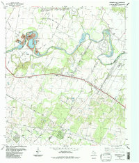 1987 Webberville1988 Print · USGSEast of Austin in the late eighties, the Colorado River corridor preserves a network of rural settlements and family burial grounds. Genealogists can locate several historic sites including Comanche Cemeteries, Haynie Cem, and Fowler Cem.
End of results
Showing maps 1-3 of 3
Top cities near Webberville
- Austin historical maps
- Pflugerville historical maps
- Manor historical maps
- Elgin historical maps
- Bastrop historical maps
- Mustang Ridge historical maps
See more
Frequently asked questions
- What are the different types of historical maps available for Webberville?
- What is the oldest map of Webberville?
- Where can I purchase historical maps of Webberville for my home or office?
- Where can I download high-res historical maps of Webberville?
- Are there historical topographic maps available for Webberville?
- Is there historical aerial imagery available for Webberville?
- Where are historical maps of Webberville sourced from?