1900s (20th Century) Maps of Big Sandy, Texas
Explore 6 historic maps of Big Sandy from the 1900s (20th Century). These maps offer a rare glimpse into what life looked like during the 1900s — showing old roads, neighborhoods, homes, and landmarks that have changed or disappeared over time.
Whether you're researching your family's past, planning a metal detecting trip, or studying how Big Sandy's landscape evolved across the 1900s, these high-resolution maps are a powerful tool for exploring the history of this region.
- Focus on a specific era: All maps on this page are from the 1900s, giving you a focused view of this time period.
- See what’s changed: Compare century-old streets, trails, and buildings to today's modern landscape using overlays and satellite layers.
- Research with precision: Use these maps for genealogy, historical research, land use analysis, or educational projects.
- View, download, or print: Maps are fully viewable online in high resolution, and can be downloaded or printed for your own records.
Start exploring Big Sandy's history through authentic maps from the 1900s. This is your window into the past.
Big Sandy, TX maps
(6)- 1956 Map of Tyler
 1956 Tyler1956 Print · USGSEast Texas was a powerhouse of oil production and rail transport during the mid-fifties, centered on the sprawling East Texas Oil Field. Researchers can trace the heritage of industrial hubs like Kilgore, military sites such as the Longhorn Ordnance Works, and many rural landmarks like Mount Enterprise.5 unique versions available
 - 1960 Map of Hawkins, 1961 Print
 1960 Hawkins1961 Print · USGSHawkins and the Sabine River valley are shown here during the peak of the local oil boom in the early sixties. Researchers can trace family sites near Jarvis Christian College, find old burials at Liberty Cem, or locate the Hawkins Oil Field wells.3 unique versions available
 - 1960 Map of Big Sandy, 1961 Print
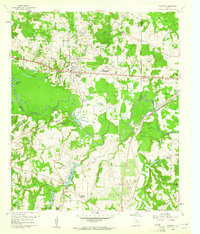
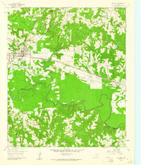 1960 Big Sandy1961 Print · USGSIn the early 1960s, this East Texas corridor was defined by the confluence of major rail lines and the Sabine River. Genealogists can trace family names and rural communities through Union Grove Ch, Chilton Cem, and the old settlement at Waters Bluff.3 unique versions available
 - 1984 Map of Tyler
 1984 Tyler1984 Print · USGSEast Texas at the peak of its reservoir-building era shows a landscape defined by new lakes and established rail corridors. Trace the path of the St Louis Southwestern RR or locate industrial sites like the Longhorn Ordnance Works.3 unique versions available
 - 1985 Map of Mineola
 1985 Mineola1985 Print · USGSUpper East Texas in the mid-eighties shows a region shaped by the Sabine River and large-scale water projects. Researchers can trace the rail heritage of the Missouri Pacific RR and locate rural landmarks like Ambassador College Res or the Oil Field.
 - 1991 Map of Mineola
 1991 Mineola1991 Print · USGSEast Texas in the early nineties reveals a landscape shaped by large-scale water reservoirs and the enduring footprint of the oil industry. Genealogists and historians can trace rail-town development in Mineola or explore smaller settlements like Bright Star and Garden Valley.
End of results
Showing maps 1-6 of 6
Top cities near Big Sandy
- Tyler historical maps
- Kilgore historical maps
- Gladewater historical maps
- Gilmer historical maps
- Holly Lake Ranch historical maps
- Liberty City historical maps
See more
Frequently asked questions
- What are the different types of historical maps available for Big Sandy?
- What is the oldest map of Big Sandy?
- Where can I purchase historical maps of Big Sandy for my home or office?
- Where can I download high-res historical maps of Big Sandy?
- Are there historical topographic maps available for Big Sandy?
- Is there historical aerial imagery available for Big Sandy?
- Where are historical maps of Big Sandy sourced from?