1960s Maps of LaFayette, Texas
Explore 1 historic maps of LaFayette from the 1960s. These maps offer a rare glimpse into what life looked like during the 1960s — showing old roads, neighborhoods, homes, and landmarks that have changed or disappeared over time.
Whether you're researching your family's past, planning a metal detecting trip, or studying how LaFayette's landscape evolved across the 1960s, these high-resolution maps are a powerful tool for exploring the history of this region.
- Focus on a specific era: All maps on this page are from the 1960s, giving you a focused view of this time period.
- See what’s changed: Compare century-old streets, trails, and buildings to today's modern landscape using overlays and satellite layers.
- Research with precision: Use these maps for genealogy, historical research, land use analysis, or educational projects.
- View, download, or print: Maps are fully viewable online in high resolution, and can be downloaded or printed for your own records.
Start exploring LaFayette's history through authentic maps from the 1960s. This is your window into the past.
LaFayette, TX maps
(1)- 1960 Map of La Fayette, 1962 Print
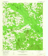 1960 La Fayette1962 Print · USGSUpper East Texas is shown here at the dawn of the sixties, just as the rising waters of the newly formed Lake O' the Pines began to reshape the Big Cypress Creek basin. Researchers can pinpoint rural life at LaFayette and Holly Springs, or trace family sites like Pleasant Grove Cem and Slaton Cem.2 unique versions available
End of results
Showing maps 1-1 of 1
Top cities near LaFayette
- Mount Pleasant historical maps
- Gilmer historical maps
- Pittsburg historical maps
- Daingerfield historical maps
- Hughes Springs historical maps
- Lone Star historical maps
See more
Frequently asked questions
- What are the different types of historical maps available for LaFayette?
- What is the oldest map of LaFayette?
- Where can I purchase historical maps of LaFayette for my home or office?
- Where can I download high-res historical maps of LaFayette?
- Are there historical topographic maps available for LaFayette?
- Is there historical aerial imagery available for LaFayette?
- Where are historical maps of LaFayette sourced from?