
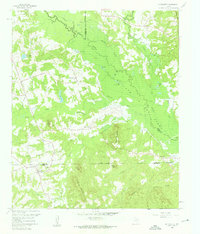
1960 Map of La Fayette
USGS Topo · Published 1962About this map
Big Cypress Creek and its complex network of sloughs and tributaries dominate this East Texas landscape at the start of the 1960s. The topographic detail captures the initial footprint of Lake O' the Pines as it inundates the lowlands of the Titus and Morris County border. The settlement of LaFayette serves as a primary local hub, surrounded by family-named landmarks and rural institutions that define the social fabric of the era.
Find a feature on this map
56 named features on this map. Tap any name to fly to it.
Don’t see what you’re looking for? This feature index may not catch every label — zoom into the map to look around manually.
Map Details
Editions of this 1960 La Fayette Map
2 editions found
Other maps of this area

1914 · Daingerfield
USGS Topo · 1:62,500

1953 · Texarkana
USGS Topo · 1:250,000

1956 · Texarkana
USGS Topo · 1:250,000

1956 · Tyler
USGS Topo · 1:250,000

1960 · Bettie
USGS Topo · 1:24,000

1960 · Coffeeville
USGS Topo · 1:24,000

1960 · Pittsburg
USGS Topo · 1:24,000

1962 · Ore City
USGS Topo · 1:24,000

1962 · Lone Star
USGS Topo · 1:24,000

1964 · Harvard
USGS Topo · 1:24,000