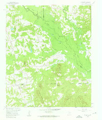
1960 Map of La Fayette
USGS Topo · Published 1962About this map
Lafayette serves as a quiet local hub in this survey of East Texas, where the landscape is defined by the transitioning waters of the Big Cypress Creek valley. At this time in the early 1960s, the formation of Lake O' the Pines was reshaping the region's geography, flooding lowlands and altering the drainage of creeks like Greasy Creek and Prairie Creek. The map documents a rural community structure established around country crossroads and high ground, with several churches and cemeteries serving as local landmarks. Notable elevations such as Couch Mountain and Adams Mountain rise above the bottomlands, while family-named features like Wilks Mtn and Pat Miller Hill suggest the deep-rooted personal history of the land. Small lakes and ponds, including Pine Ridge Club Lake and Flanagan Lake, dot the terrain alongside scattered gravel pits and pipelines, illustrating the area's mixed focus on recreation and natural resource extraction.
Find a feature on this map
51 named features on this map. Tap any name to fly to it.
Don’t see what you’re looking for? This feature index may not catch every label — zoom into the map to look around manually.
Map Details
Editions of this 1960 La Fayette Map
2 editions found
Other maps of this area

1914 · Daingerfield
USGS Topo · 1:62,500

1953 · Texarkana
USGS Topo · 1:250,000

1956 · Texarkana
USGS Topo · 1:250,000

1956 · Tyler
USGS Topo · 1:250,000

1960 · Bettie
USGS Topo · 1:24,000

1960 · Coffeeville
USGS Topo · 1:24,000

1960 · La Fayette
USGS Topo · 1:24,000

1960 · Pittsburg
USGS Topo · 1:24,000

1962 · Ore City
USGS Topo · 1:24,000

1962 · Lone Star
USGS Topo · 1:24,000