1900s (20th Century) Maps of Utopia, Texas
Explore 5 historic maps of Utopia from the 1900s (20th Century). These maps offer a rare glimpse into what life looked like during the 1900s — showing old roads, neighborhoods, homes, and landmarks that have changed or disappeared over time.
Whether you're researching your family's past, planning a metal detecting trip, or studying how Utopia's landscape evolved across the 1900s, these high-resolution maps are a powerful tool for exploring the history of this region.
- Focus on a specific era: All maps on this page are from the 1900s, giving you a focused view of this time period.
- See what’s changed: Compare century-old streets, trails, and buildings to today's modern landscape using overlays and satellite layers.
- Research with precision: Use these maps for genealogy, historical research, land use analysis, or educational projects.
- View, download, or print: Maps are fully viewable online in high resolution, and can be downloaded or printed for your own records.
Start exploring Utopia's history through authentic maps from the 1900s. This is your window into the past.
Utopia, TX maps
(5)- 1954 Map of San Antonio, 1964 Print
 1954 San Antonio1964 Print · USGSSan Antonio and the Texas Hill Country are captured here in the mid-fifties, showing a landscape defined by massive military air bases and the rising Canyon Reservoir. Trace family ties through historic rail towns like D'Hanis and Castroville or explore the Cold War footprint of Lackland AFB and Randolph AFB.3 unique versions available
 - 1956 Map of Utopia
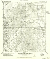 1956 Utopia1956 Print · USGSThe Sabinal and Frio River valleys are mapped here during the mid-twentieth century, showcasing a transition from pioneer homesteads to established ranching. Genealogists and historians can trace family locations like Paterson Ranch or find vanished landmarks like Thompsons Mill and Taylor School.
 - 1957 Map of San Antonio
 1957 San Antonio1957 Print · USGSSan Antonio and the Texas Hill Country are shown here during the mid-fifties, capturing the region's expanding post-war military and transportation footprint. Genealogists and local historians can trace the early residential boundaries of Alamo Heights or locate rural landmarks like St Hedwig and Medina Lake.
 - 1969 Map of Utopia, 1972 Print
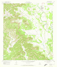 1969 Utopia1972 Print · USGSThe Sabinal River valley in the late sixties shows a landscape of small settlements and Hill Country ranching. Genealogy researchers can locate the Waresville Cem and High Sch, or trace family landmarks like Blanco Ranch and Bald Mountain.
 - 1985 Map of Bandera
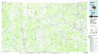 1985 Bandera1985 Print · USGSThe Texas Hill Country in the mid-eighties was a land of winding river valleys and high limestone ridges. You can trace the rural road networks and find local landmarks like Garner State Park, Utopia, and Lost Maples State Park.2 unique versions available
End of results
Showing maps 1-5 of 5
Frequently asked questions
- What are the different types of historical maps available for Utopia?
- What is the oldest map of Utopia?
- Where can I purchase historical maps of Utopia for my home or office?
- Where can I download high-res historical maps of Utopia?
- Are there historical topographic maps available for Utopia?
- Is there historical aerial imagery available for Utopia?
- Where are historical maps of Utopia sourced from?