Old Maps of Del Rio, Texas for Academic Research
Study the evolution of Del Rio with 28 high-resolution historic maps. Whether you're teaching, researching, or modeling changes in land use, these maps provide essential visual documentation of urban, environmental, and geographic change.
- Analyze long-term change: Track patterns in development, transportation, and natural features.
- Ideal for environmental or urban studies: Support academic projects with primary historical map data.
- Use in the classroom or lab: Educators and researchers rely on these maps to bring historical context to life.
These maps are a powerful tool for teaching, research, and visualizing how Del Rio has changed over the decades.
Del Rio, TX maps
(28)- 1943 Map of Del Rio, 1969 Print
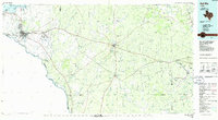
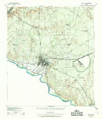 1943 Del Rio1969 Print · USGSDel Rio and the Rio Grande borderlands are captured here during the mobilization of the early 1940s. Researchers can trace family ranching history at Brite Ranch or locate the burgeoning military operations at Laughlin Field.
 - 1958 Map of Del Rio, 1970 Print
 1958 Del Rio1970 Print · USGSThe Texas-Mexico borderlands come alive in the late fifties, showing the confluence of the Rio Grande and the emerging Amistad Reservoir. Trace the lineage of the Southern Pacific rail line through stops at Pumpville, Shumla, and the mining vicinity of Blewett.2 unique versions available
 - 1964 Map of Del Rio
 1964 Del Rio1964 Print · USGSAlong the Mexican border during the mid-sixties, this area centered on the confluence of the Rio Grande and Devils River. Researchers can trace the Southern Pacific line through isolated stops like Pumpville or locate military and industrial sites such as Laughlin Air Force Base and the mines at Blewett.
 - 1972 Map of Del Rio SW, 1975 Print
 1972 Del Rio SW1975 Print · USGSThe Texas-Mexico border at Del Rio comes into sharp focus during the early 1970s, as the town expanded toward the river. Genealogists and local historians can trace family locations near San Felipe Sprs, the Old San Felipe Cem, and Sacred Heart Academy.
 - 1972 Map of Del Rio SE, 1975 Print
 1972 Del Rio SE1975 Print · USGSThe Texas-Mexico borderlands come into sharp focus in the early seventies, centered on the strategic presence of Laughlin Air Force Base. Trace the rugged drainages of Zorro Creek and Sacatosa Creek as they meet the Rio Grande.
 - 1972 Map of Del Rio NW, 1975 Print
 1972 Del Rio NW1975 Print · USGSDel Rio and the neighboring settlement of Cantu are captured in the early 1970s just as the newly formed Amistad Reservoir reshaped the local landscape. Genealogists and historians can locate specific properties along Bedell Ave or trace landmarks like Val Verde Memorial Hospital and the Fish Hatchery.
 - 1972 Map of Del Rio NE, 1975 Print
 1972 Del Rio NE1975 Print · USGSThe high plains of Val Verde County are captured here in the early seventies as the region adapted to the new Amistad Reservoir. Researchers can trace the Old Railroad Grade and locate the airfield at Laughlin Air Force Base near the settlement of Johnstone.
 - 1986 Map of Del Rio
 1986 Del Rio1986 Print · USGSThe West Texas borderlands come alive in the mid-eighties as Del Rio expands and Laughlin AFB anchors the local economy. Researchers can trace the rail corridors through Spofford and Cline or locate family sites near Alamo Village.2 unique versions available
 - 2010 Map of Del Rio NW, 2010 Print
 2010 Del Rio NW2010 Print · USGSCovers Del Rio, including Lake View, Lake View Addition Colonia, and other nearby areas
 - 2010 Map of Del Rio SE, 2010 Print
 2010 Del Rio SE2010 Print · USGSCovers Del Rio, including Val Verde Park, Val Verde Park Number 2 Colonia, and other nearby areas
 - 2010 Map of Del Rio NE, 2010 Print
 2010 Del Rio NE2010 Print · USGSCovers Del Rio, including Johnstone, Val Verde County, and other nearby areas
 - 2010 Map of Del Rio SW, 2010 Print
 2010 Del Rio SW2010 Print · USGSCovers Del Rio, including Ciudad Acuña, Las Torres, and other nearby areas
 - 2013 Map of Del Rio NE, 2013 Print
 2013 Del Rio NE2013 Print · USGSCovers Del Rio, including Johnstone, Val Verde County, and other nearby areas
 - 2013 Map of Del Rio NW, 2013 Print
 2013 Del Rio NW2013 Print · USGSCovers Del Rio, including Lake View, Lake View Addition Colonia, and other nearby areas
 - 2013 Map of Del Rio SE, 2013 Print
 2013 Del Rio SE2013 Print · USGSCovers Del Rio, including Val Verde Park, Val Verde Park Number 2 Colonia, and other nearby areas
 - 2013 Map of Del Rio SW, 2013 Print
 2013 Del Rio SW2013 Print · USGSCovers Del Rio, including Ciudad Acuña, Las Torres, and other nearby areas
 - 2016 Map of Del Rio SW, 2016 Print
 2016 Del Rio SW2016 Print · USGSCovers Del Rio, including Ciudad Acuña, Las Torres, and other nearby areas
 - 2016 Map of Del Rio SE, 2016 Print
 2016 Del Rio SE2016 Print · USGSCovers Del Rio, including Val Verde Park, Val Verde Park Number 2 Colonia, and other nearby areas
 - 2016 Map of Del Rio NE, 2016 Print
 2016 Del Rio NE2016 Print · USGSCovers Del Rio, including Johnstone, Val Verde County, and other nearby areas
 - 2016 Map of Del Rio NW, 2016 Print
 2016 Del Rio NW2016 Print · USGSCovers Del Rio, including Lake View, Lake View Addition Colonia, and other nearby areas
 - 2019 Map of Del Rio SE, 2019 Print
 2019 Del Rio SE2019 Print · USGSCovers Del Rio, including Val Verde Park, Val Verde Park Number 2 Colonia, and other nearby areas
 - 2019 Map of Del Rio SW, 2019 Print
 2019 Del Rio SW2019 Print · USGSCovers Del Rio, including Ciudad Acuña, Las Torres, and other nearby areas
 - 2019 Map of Del Rio NW, 2019 Print
 2019 Del Rio NW2019 Print · USGSCovers Del Rio, including Lake View, Lake View Addition Colonia, and other nearby areas
 - 2019 Map of Del Rio NE, 2019 Print
 2019 Del Rio NE2019 Print · USGSCovers Del Rio, including Johnstone, Val Verde County, and other nearby areas
 - 2022 Map of Del Rio SW, 2022 Print
 2022 Del Rio SW2022 Print · USGSThe Texas-Mexico borderlands at Del Rio come into focus on this 2022 survey, showing a landscape shaped by the Rio Grande and San Felipe Creek. Genealogists can trace family connections through the Old San Felipe Cem and the Val Verde County Courthouse.
Showing maps 1-25 of 28
Top cities near Del Rio
Frequently asked questions
- What are the different types of historical maps available for Del Rio?
- What is the oldest map of Del Rio?
- Where can I purchase historical maps of Del Rio for my home or office?
- Where can I download high-res historical maps of Del Rio?
- Are there historical topographic maps available for Del Rio?
- Is there historical aerial imagery available for Del Rio?
- Where are historical maps of Del Rio sourced from?