Old Maps of Devils Shores, Texas for Academic Research
Study the evolution of Devils Shores with 10 high-resolution historic maps. Whether you're teaching, researching, or modeling changes in land use, these maps provide essential visual documentation of urban, environmental, and geographic change.
- Analyze long-term change: Track patterns in development, transportation, and natural features.
- Ideal for environmental or urban studies: Support academic projects with primary historical map data.
- Use in the classroom or lab: Educators and researchers rely on these maps to bring historical context to life.
These maps are a powerful tool for teaching, research, and visualizing how Devils Shores has changed over the decades.
Devils Shores, TX maps
(10)- 1944 Map of Devils Lake
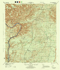 1944 Devils Lake1944 Print · USGSVal Verde County ranching country is documented in detail during the early 1940s, highlighting the isolated homesteads of the West Texas plateau. Researchers can trace family-named holdings like Goldwire Ranch and H Miers Fourteen Mile Ranch along the banks of Devils River Lake.2 unique versions available
 - 1958 Map of Del Rio, 1970 Print
 1958 Del Rio1970 Print · USGSThe Texas-Mexico borderlands come alive in the late fifties, showing the confluence of the Rio Grande and the emerging Amistad Reservoir. Trace the lineage of the Southern Pacific rail line through stops at Pumpville, Shumla, and the mining vicinity of Blewett.2 unique versions available
 - 1964 Map of Del Rio
 1964 Del Rio1964 Print · USGSAlong the Mexican border during the mid-sixties, this area centered on the confluence of the Rio Grande and Devils River. Researchers can trace the Southern Pacific line through isolated stops like Pumpville or locate military and industrial sites such as Laughlin Air Force Base and the mines at Blewett.
 - 1972 Map of Rough Canyon, 1975 Print
 1972 Rough Canyon1975 Print · USGSThe canyons of Val Verde County are shown just as the rising reservoir waters reshaped the terrain in the early seventies. Trace the emerging shoreline at Devils Shores or the early recreational developments at Rough Canyon Marina and the Boat Ramp.
 - 1985 Map of Camp Wood, 1986 Print
 1985 Camp Wood1986 Print · USGSThe Edwards Plateau and Nueces River Valley are captured here in the mid-eighties, showing a landscape of isolated ranching hubs and rugged drainage basins. Researchers can trace the Old Railroad Grade or locate historic springs like Dripping Springs and Red Camp Spring.2 unique versions available
 - 2010 Map of Rough Canyon, 2010 Print
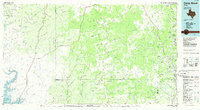
 2010 Rough Canyon2010 Print · USGSCovers Devils Shores, including Rough Canyon Colonia, Val Verde County, and other nearby areas
 - 2013 Map of Rough Canyon, 2013 Print
 2013 Rough Canyon2013 Print · USGSCovers Devils Shores, including Rough Canyon Colonia, Val Verde County, and other nearby areas
 - 2016 Map of Rough Canyon, 2016 Print
 2016 Rough Canyon2016 Print · USGSCovers Devils Shores, including Rough Canyon Colonia, Val Verde County, and other nearby areas
 - 2019 Map of Rough Canyon, 2019 Print
 2019 Rough Canyon2019 Print · USGSCovers Devils Shores, including Rough Canyon Colonia, Val Verde County, and other nearby areas
 - 2022 Map of Rough Canyon, 2022 Print
 2022 Rough Canyon2022 Print · USGSVal Verde County's dramatic canyonlands are mapped here in the early twenty-first century, showing the intersection of the Devils River and the Amistad National Recreation Area. Outdoorsmen and researchers can trace access points like Hunt Area 4 Access or find landmarks such as Walk Lake and the Rough Canyon Cliffs.
End of results
Showing maps 1-10 of 10
Top cities near Devils Shores
Frequently asked questions
- What are the different types of historical maps available for Devils Shores?
- What is the oldest map of Devils Shores?
- Where can I purchase historical maps of Devils Shores for my home or office?
- Where can I download high-res historical maps of Devils Shores?
- Are there historical topographic maps available for Devils Shores?
- Is there historical aerial imagery available for Devils Shores?
- Where are historical maps of Devils Shores sourced from?