1940s Maps of Rough Canyon Colonia, Texas
Explore 1 historic maps of Rough Canyon Colonia from the 1940s. These maps offer a rare glimpse into what life looked like during the 1940s — showing old roads, neighborhoods, homes, and landmarks that have changed or disappeared over time.
Whether you're researching your family's past, planning a metal detecting trip, or studying how Rough Canyon Colonia's landscape evolved across the 1940s, these high-resolution maps are a powerful tool for exploring the history of this region.
- Focus on a specific era: All maps on this page are from the 1940s, giving you a focused view of this time period.
- See what’s changed: Compare century-old streets, trails, and buildings to today's modern landscape using overlays and satellite layers.
- Research with precision: Use these maps for genealogy, historical research, land use analysis, or educational projects.
- View, download, or print: Maps are fully viewable online in high resolution, and can be downloaded or printed for your own records.
Start exploring Rough Canyon Colonia's history through authentic maps from the 1940s. This is your window into the past.
Rough Canyon Colonia, TX maps
(1)- 1944 Map of Devils Lake
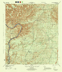 1944 Devils Lake1944 Print · USGSVal Verde County ranching country is documented in detail during the early 1940s, highlighting the isolated homesteads of the West Texas plateau. Researchers can trace family-named holdings like Goldwire Ranch and H Miers Fourteen Mile Ranch along the banks of Devils River Lake.2 unique versions available
End of results
Showing maps 1-1 of 1
Top cities near Rough Canyon Colonia
- Del Rio historical maps
- Val Verde Park historical maps
- Comstock historical maps
- Lake View historical maps
Frequently asked questions
- What are the different types of historical maps available for Rough Canyon Colonia?
- What is the oldest map of Rough Canyon Colonia?
- Where can I purchase historical maps of Rough Canyon Colonia for my home or office?
- Where can I download high-res historical maps of Rough Canyon Colonia?
- Are there historical topographic maps available for Rough Canyon Colonia?
- Is there historical aerial imagery available for Rough Canyon Colonia?
- Where are historical maps of Rough Canyon Colonia sourced from?