
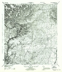
1944 Map of Devils Lake
USGS Topo · Published 1944About this map
The Devils River Lake wind through the stark landscape of Val Verde County in this mid-century survey prepared by the Corps of Engineers, U.S. Army. The terrain is defined by deep incisions like Rough Canyon and the sharp curve of Slaughter Bend, where the river carves through the limestone plateau. While much of the land remains divided into expansive voting precincts such as Precinct 5 and Precinct 12, the map meticulously documents the network of remote ranching operations that supported the regional economy. Large family holdings including the Goldwire Ranch, Cauthorn Ranch, and H Miers Fourteen Mile Ranch are noted, providing a valuable record for genealogists tracing these specific West Texas surnames. The presence of 277 and 41 indicates the slowly developing transportation corridor connecting this border region to the interior during the war years.
Find a feature on this map
31 named features on this map. Tap any name to fly to it.
Don’t see what you’re looking for? This feature index may not catch every label — zoom into the map to look around manually.
Map Details
Editions of this 1944 Devils Lake Map
2 editions found
Other maps of this area

1941 · Standart
USGS Topo · 1:62,500

1941 · Feely
USGS Topo · 1:62,500

1943 · Carta Valley
USGS Topo · 1:62,500

1943 · Standart
USGS Topo · 1:62,500

1943 · Devils River
USGS Topo · 1:62,500

1943 · Del Rio
USGS Topo · 1:62,500

1944 · Devils River
USGS Topo · 1:62,500

1944 · Flat Rock
USGS Topo · 1:62,500

1944 · Dry Devil
USGS Topo · 1:62,500

1944 · Baker Crossing
USGS Topo · 1:62,500