1900s (20th Century) Maps of Victoria, Texas
Explore 11 historic maps of Victoria from the 1900s (20th Century). These maps offer a rare glimpse into what life looked like during the 1900s — showing old roads, neighborhoods, homes, and landmarks that have changed or disappeared over time.
Whether you're researching your family's past, planning a metal detecting trip, or studying how Victoria's landscape evolved across the 1900s, these high-resolution maps are a powerful tool for exploring the history of this region.
- Focus on a specific era: All maps on this page are from the 1900s, giving you a focused view of this time period.
- See what’s changed: Compare century-old streets, trails, and buildings to today's modern landscape using overlays and satellite layers.
- Research with precision: Use these maps for genealogy, historical research, land use analysis, or educational projects.
- View, download, or print: Maps are fully viewable online in high resolution, and can be downloaded or printed for your own records.
Start exploring Victoria's history through authentic maps from the 1900s. This is your window into the past.
Victoria, TX maps
(11)- 1951 Map of Inez NW, 1953 Print
 1951 Inez NW1953 Print · USGSVictoria County ranch lands were transitioning into an early energy frontier during the early fifties. Genealogists and historians can trace community hubs like Salem and Mt Pisgah Ch alongside infrastructure like a Gas Collecting Station.2 unique versions available
 - 1952 Map of Victoria East, 1953 Print
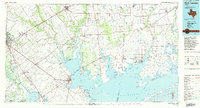
 1952 Victoria East1953 Print · USGSVictoria enters the early fifties as a thriving center of energy and education. Trace local family history and industrial growth through sites like Victoria College, the Foster Field airbase, and community hubs like Mt Olive Ch.2 unique versions available
 - 1953 Map of Beeville
 1953 Beeville1953 Print · USGSThe Texas Coastal Bend in the early fifties shows a landscape of growing regional hubs and vital maritime corridors. Trace the rail-and-river economy through Goliad, locate the Matagorda Lighthouse, and explore the sprawling Aransas National Wildlife Refuge.
 - 1956 Map of Beeville
 1956 Beeville1956 Print · USGSCoastal Texas and the brush country interior are shown in the mid-fifties, from the coastal bays to the inland oil fields. Trace the old rail lines of the Southern Pacific RR or locate the historic Matagorda Lighthouse and the Aransas National Wildlife Refuge.2 unique versions available
 - 1960 Map of Beeville
 1960 Beeville1960 Print · USGSCoastal Texas in the mid-fifties reveals a landscape of growing towns and vital military outposts like Foster AFB. Researchers can trace old rail lines including the Missouri Pacific and explore the vast Aransas National Wildlife Refuge.
 - 1963 Map of Nursery, 1965 Print
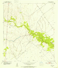
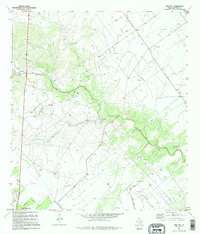
 1963 Nursery1965 Print · USGSVictoria County during the early sixties shows a landscape defined by the Guadalupe River and the Southern Pacific rail line. Researchers can locate the settlement of Nursery, the Nursery Cem, and family landmarks like Fordtran Road or the Ball Airport.3 unique versions available
 - 1964 Map of Victoria West, 1965 Print
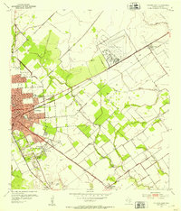
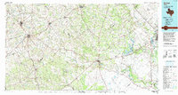
 1964 Victoria West1965 Print · USGSVictoria and its western outskirts are captured in the mid-sixties as oil fields and aviation history shaped the landscape. Trace local landmarks like Aloe Field, the Murphy Cem, and the winding Guadalupe River oxbows.4 unique versions available
 - 1984 Map of Port Lavaca
 1984 Port Lavaca1984 Print · USGSCoastal Texas in the mid-1980s reveals a landscape of industrial waterways and historic rail corridors. Genealogists and historians can trace family roots through settlements like Bloomington and La Ward or explore the transit networks of the Southern Pacific and Missouri Pacific.
 - 1985 Map of Goliad, 1992 Print
 1985 Goliad1992 Print · USGSThe South Texas plains during the mid-eighties reveal a landscape of deep-rooted ranching towns and historic river crossings. Genealogists and historians can trace family locations through Upper Meyersville, follow the Southern Pacific rail line, or locate landmarks like OLF Goliad and Goliad State Park.
 - 1995 Map of Inez NW
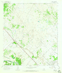
 1995 Inez NW1995 Print · USGSVictoria County's coastal plains are captured here in the mid-nineties, showing a landscape defined by ranching and energy. Researchers can locate the Salem community, Mt Pisgah Ch, and industrial traces like Spoil Bank and numerous Gas Wells.
 - 1995 Map of Victoria East
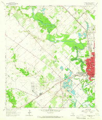
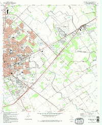 1995 Victoria East1995 Print · USGSVictoria expanded toward the Coastal Bend in the nineties, blending a deep-rooted educational landscape with industrial growth. Genealogists can trace family landmarks like Resurrection Cemetery and the Incarnate Word Convent or locate vanished sites near Telferner.
End of results
Showing maps 1-11 of 11
Top neighborhoods of Victoria
Frequently asked questions
- What are the different types of historical maps available for Victoria?
- What is the oldest map of Victoria?
- Where can I purchase historical maps of Victoria for my home or office?
- Where can I download high-res historical maps of Victoria?
- Are there historical topographic maps available for Victoria?
- Is there historical aerial imagery available for Victoria?
- Where are historical maps of Victoria sourced from?