1900s (20th Century) Maps of Mill Creek, Texas
Explore 5 historic maps of Mill Creek from the 1900s (20th Century). These maps offer a rare glimpse into what life looked like during the 1900s — showing old roads, neighborhoods, homes, and landmarks that have changed or disappeared over time.
Whether you're researching your family's past, planning a metal detecting trip, or studying how Mill Creek's landscape evolved across the 1900s, these high-resolution maps are a powerful tool for exploring the history of this region.
- Focus on a specific era: All maps on this page are from the 1900s, giving you a focused view of this time period.
- See what’s changed: Compare century-old streets, trails, and buildings to today's modern landscape using overlays and satellite layers.
- Research with precision: Use these maps for genealogy, historical research, land use analysis, or educational projects.
- View, download, or print: Maps are fully viewable online in high resolution, and can be downloaded or printed for your own records.
Start exploring Mill Creek's history through authentic maps from the 1900s. This is your window into the past.
Mill Creek, TX maps
(5)- 1930 Map of Brenham, 1937 Print
 1930 Brenham1937 Print · USGSBrenham and Chapel Hill appear here during the interwar years as vital rail and agricultural centers for Washington County. Researchers can trace rural life through numerous labeled landmarks like the County Farm, Harrison Spring Church, and Polaski School.
 - 1954 Map of Austin, 1964 Print
 1954 Austin1964 Print · USGSCentral Texas is captured during a period of steady growth as the capital city and its neighboring farm towns began to modernize. Researchers can trace historic rail corridors like the Southern Pacific RR or locate landmarks such as Bergstrom Air Force Base and Pilot Knob.4 unique versions available
 - 1956 Map of Brenham
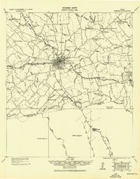
 1956 Brenham1956 Print · USGSWashington County during the early twentieth century was a landscape of rail-connected towns and rural parish life. Genealogists can trace family locations near landmarks like Harrison Spring Church, Polaski School, and the County Farm.
 - 1963 Map of Brenham, 1966 Print
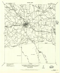
 1963 Brenham1966 Print · USGSBrenham and the surrounding Washington County countryside are captured here in the early sixties as a thriving railroad and agricultural center. Local historians can trace family roots at Prairie Lea Cemetery, Yellow Fever Cem, or rural churches like St Johns Ch.3 unique versions available
 - 1993 Map of Brenham
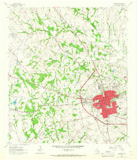
 1993 Brenham1993 Print · USGSTexas river country and the birthplace of the republic are showcased in the early nineties, centered on the confluence of the Brazos and Navasota. Researchers can trace the rail sidings of the Southern Pacific RR and locate historic community landmarks like St Paul Ch and Washington-on-the-Brazos State Park.
End of results
Showing maps 1-5 of 5
Top cities near Mill Creek
- Brenham historical maps
- Bellville historical maps
- Somerville historical maps
- Burton historical maps
- Industry historical maps
- Carmine historical maps
See more
Frequently asked questions
- What are the different types of historical maps available for Mill Creek?
- What is the oldest map of Mill Creek?
- Where can I purchase historical maps of Mill Creek for my home or office?
- Where can I download high-res historical maps of Mill Creek?
- Are there historical topographic maps available for Mill Creek?
- Is there historical aerial imagery available for Mill Creek?
- Where are historical maps of Mill Creek sourced from?