Old Maps of Las Tiendas, Texas for Academic Research
Study the evolution of Las Tiendas with 9 high-resolution historic maps. Whether you're teaching, researching, or modeling changes in land use, these maps provide essential visual documentation of urban, environmental, and geographic change.
- Analyze long-term change: Track patterns in development, transportation, and natural features.
- Ideal for environmental or urban studies: Support academic projects with primary historical map data.
- Use in the classroom or lab: Educators and researchers rely on these maps to bring historical context to life.
These maps are a powerful tool for teaching, research, and visualizing how Las Tiendas has changed over the decades.
Las Tiendas, TX maps
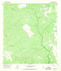
(9)- 1956 Map of Las Tiendas
 1956 Las Tiendas1956 Print · USGSThe South Texas ranching country of Webb County is meticulously mapped during the late twenties and thirties, showing a vast network of family cattle spreads. Genealogists and historians can trace the boundaries of the Las Tiendas Ranch, Casa Blanca Ranch, and Centeno Ranch across this semi-arid landscape.
 - 1956 Map of Laredo, 1960 Print
 1956 Laredo1960 Print · USGSSouth Texas in the mid-fifties reveals a landscape shaped by border commerce, military aviation, and a booming oil industry. Trace the historic Texas and Mexican RR line through Hebbronville or locate the sprawling Mirando City Oil Field and Laredo AFB.3 unique versions available
 - 1965 Map of Las Tiendas, 1967 Print
 1965 Las Tiendas1967 Print · USGSWebb County ranching country is captured here in the mid-1960s, showing a landscape of scattered family outposts and vital water management. Researchers can trace the layout of Las Tiendas, locate the Hearne Ranch, and identify numerous stock tanks like Jefferies Tank.2 unique versions available
 - 1985 Map of Laredo
 1985 Laredo1985 Print · USGSThe Rio Grande border and the expanding city of Laredo are captured in the mid-eighties as a major international transit hub. Trace the development of Del Mar, the routes of the Texas Mexican railroad, and outlying settlements like Islitas and Las Tiendas.3 unique versions available
 - 2010 Map of Las Tiendas, 2010 Print
 2010 Las Tiendas2010 Print · USGSCovers Las Tiendas, including Webb County, United States, and other nearby areas
 - 2013 Map of Las Tiendas, 2013 Print
 2013 Las Tiendas2013 Print · USGSCovers Las Tiendas, including Webb County, United States, and other nearby areas
 - 2016 Map of Las Tiendas, 2016 Print
 2016 Las Tiendas2016 Print · USGSCovers Las Tiendas, including Webb County, United States, and other nearby areas
 - 2019 Map of Las Tiendas, 2019 Print
 2019 Las Tiendas2019 Print · USGSCovers Las Tiendas, including Webb County, United States, and other nearby areas
 - 2022 Map of Las Tiendas, 2022 Print
 2022 Las Tiendas2022 Print · USGSWebb County ranch lands in the early 2020s are defined by a network of essential water tanks and private ranch roads. Researchers can trace the landscape's water management via Chupahueso Lake Number 2 and the winding course of Santa Isabel Cr.
End of results
Showing maps 1-9 of 9
Top cities near Las Tiendas
Frequently asked questions
- What are the different types of historical maps available for Las Tiendas?
- What is the oldest map of Las Tiendas?
- Where can I purchase historical maps of Las Tiendas for my home or office?
- Where can I download high-res historical maps of Las Tiendas?
- Are there historical topographic maps available for Las Tiendas?
- Is there historical aerial imagery available for Las Tiendas?
- Where are historical maps of Las Tiendas sourced from?