Old Maps of Minera, Texas
Explore 8 old maps of Minera, spanning from 1956 to today. These high-resolution historic maps reveal how streets, neighborhoods, landmarks, and natural features evolved over time — perfect for genealogy, metal detecting, research, and local history exploration.
What you can do with these maps:
- See how Minera changed over time: Compare historical maps to modern-day views to trace roads, homesites, rail lines & more.
- View detailed metadata: Each map includes creators, publishers, year, scale, and archive source.
- Overlay maps with satellite & LiDAR: Visualize the past alongside modern tools to explore terrain & human change.
- Trusted historical sources: Maps sourced from the USGS, Library of Congress, and other archives.
- Access maps your way: View online, download high-res files, or order prints for personal or research use.
Start exploring old maps of Minera to uncover forgotten places, hidden landmarks, and the deep history beneath your feet.
Minera, TX maps
(8)- 1956 Map of Laredo, 1960 Print
 1956 Laredo1960 Print · USGSSouth Texas in the mid-fifties reveals a landscape shaped by border commerce, military aviation, and a booming oil industry. Trace the historic Texas and Mexican RR line through Hebbronville or locate the sprawling Mirando City Oil Field and Laredo AFB.3 unique versions available
 - 1983 Map of Fort McIntosh 3 NE
 1983 Fort McIntosh 3 NE1983 Print · USGSThe Texas-Mexico borderlands along the Rio Grande are captured here in the early eighties as a network of rural ranchos and river crossings. Researchers can trace the layout of international boundary markers and local sites like Colombia, Rancho Nuevo, and San Vicente.2 unique versions available
 - 1985 Map of Laredo
 1985 Laredo1985 Print · USGSThe Rio Grande border and the expanding city of Laredo are captured in the mid-eighties as a major international transit hub. Trace the development of Del Mar, the routes of the Texas Mexican railroad, and outlying settlements like Islitas and Las Tiendas.3 unique versions available
 - 2010 Map of South of San Pedro Hill, 2010 Print
 2010 South of San Pedro Hill2010 Print · USGSCovers Minera, including Laredo, Colombia, and other nearby areas
 - 2013 Map of South of San Pedro Hill, 2013 Print
 2013 South of San Pedro Hill2013 Print · USGSCovers Minera, including Laredo, Colombia, and other nearby areas
 - 2016 Map of South of San Pedro Hill, 2016 Print
 2016 South of San Pedro Hill2016 Print · USGSCovers Minera, including Laredo, Colombia, and other nearby areas
 - 2019 Map of South of San Pedro Hill, 2019 Print
 2019 South of San Pedro Hill2019 Print · USGSCovers Minera, including Laredo, Colombia, and other nearby areas
 - 2022 Map of South of San Pedro Hill, 2022 Print
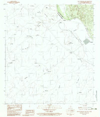
 2022 South of San Pedro Hill2022 Print · USGSThe international borderlands northwest of Laredo come into focus in this recent survey of the Texas-Mexico frontier. Researchers can trace the winding course of the Rio Grande and the development of the Mines Rd corridor as it extends from Laredo.
End of results
Showing maps 1-8 of 8
Top cities near Minera
Frequently asked questions
- What are the different types of historical maps available for Minera?
- What is the oldest map of Minera?
- Where can I purchase historical maps of Minera for my home or office?
- Where can I download high-res historical maps of Minera?
- Are there historical topographic maps available for Minera?
- Is there historical aerial imagery available for Minera?
- Where are historical maps of Minera sourced from?