Old Maps of Minera, Texas for Hiking & Exploration
Hike through history with 8 historic maps of Minera. Explore old trails, ghost towns, and forgotten backroads — perfect for outdoor adventurers and local explorers.
- Rediscover forgotten places: Map out old mining camps, roads, and footpaths that no longer exist on modern maps.
- Layer with modern tools: Combine with LiDAR or satellite views to plan hikes through historical terrain.
- Made for exploration: Popular among hikers, overlanders, and local history lovers.
Use these maps to find adventure and explore the hidden past of Minera.
Minera, TX maps
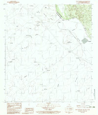
(8)- 1956 Map of Laredo, 1960 Print
 1956 Laredo1960 Print · USGSSouth Texas in the mid-fifties reveals a landscape shaped by border commerce, military aviation, and a booming oil industry. Trace the historic Texas and Mexican RR line through Hebbronville or locate the sprawling Mirando City Oil Field and Laredo AFB.3 unique versions available
 - 1983 Map of Fort McIntosh 3 NE
 1983 Fort McIntosh 3 NE1983 Print · USGSThe Texas-Mexico borderlands along the Rio Grande are captured here in the early eighties as a network of rural ranchos and river crossings. Researchers can trace the layout of international boundary markers and local sites like Colombia, Rancho Nuevo, and San Vicente.2 unique versions available
 - 1985 Map of Laredo
 1985 Laredo1985 Print · USGSThe Rio Grande border and the expanding city of Laredo are captured in the mid-eighties as a major international transit hub. Trace the development of Del Mar, the routes of the Texas Mexican railroad, and outlying settlements like Islitas and Las Tiendas.3 unique versions available
 - 2010 Map of South of San Pedro Hill, 2010 Print
 2010 South of San Pedro Hill2010 Print · USGSCovers Minera, including Laredo, Colombia, and other nearby areas
 - 2013 Map of South of San Pedro Hill, 2013 Print
 2013 South of San Pedro Hill2013 Print · USGSCovers Minera, including Laredo, Colombia, and other nearby areas
 - 2016 Map of South of San Pedro Hill, 2016 Print
 2016 South of San Pedro Hill2016 Print · USGSCovers Minera, including Laredo, Colombia, and other nearby areas
 - 2019 Map of South of San Pedro Hill, 2019 Print
 2019 South of San Pedro Hill2019 Print · USGSCovers Minera, including Laredo, Colombia, and other nearby areas
 - 2022 Map of South of San Pedro Hill, 2022 Print
 2022 South of San Pedro Hill2022 Print · USGSThe international borderlands northwest of Laredo come into focus in this recent survey of the Texas-Mexico frontier. Researchers can trace the winding course of the Rio Grande and the development of the Mines Rd corridor as it extends from Laredo.
End of results
Showing maps 1-8 of 8
Top cities near Minera
Frequently asked questions
- What are the different types of historical maps available for Minera?
- What is the oldest map of Minera?
- Where can I purchase historical maps of Minera for my home or office?
- Where can I download high-res historical maps of Minera?
- Are there historical topographic maps available for Minera?
- Is there historical aerial imagery available for Minera?
- Where are historical maps of Minera sourced from?