1960s Maps of Runaway Bay, Texas
Explore 2 historic maps of Runaway Bay from the 1960s. These maps offer a rare glimpse into what life looked like during the 1960s — showing old roads, neighborhoods, homes, and landmarks that have changed or disappeared over time.
Whether you're researching your family's past, planning a metal detecting trip, or studying how Runaway Bay's landscape evolved across the 1960s, these high-resolution maps are a powerful tool for exploring the history of this region.
- Focus on a specific era: All maps on this page are from the 1960s, giving you a focused view of this time period.
- See what’s changed: Compare century-old streets, trails, and buildings to today's modern landscape using overlays and satellite layers.
- Research with precision: Use these maps for genealogy, historical research, land use analysis, or educational projects.
- View, download, or print: Maps are fully viewable online in high resolution, and can be downloaded or printed for your own records.
Start exploring Runaway Bay's history through authentic maps from the 1960s. This is your window into the past.
Runaway Bay, TX maps
(2)- 1960 Map of Bridgeport West, 1961 Print
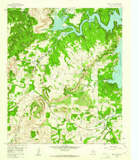
 1960 Bridgeport West1961 Print · USGSWise County's landscape in the early sixties is dominated by the sprawling shoreline of Lake Bridgeport and the rail activity in Bridgeport. Researchers can locate historic burial sites like the Oldtown Cem and Mexican Cem or trace rural landmarks like the Pleasant Valley Ch.4 unique versions available
 - 1960 Map of Wizard Wells, 1961 Print
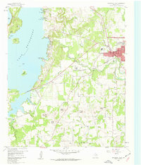
 1960 Wizard Wells1961 Print · USGSThe Jacksboro area in the early sixties is defined here by the rising waters of Lake Bridgeport and a thriving energy industry. Researchers can find Wizard Wells Cem, trace the Rock Island and Pacific line, and locate dozens of early gas wells.2 unique versions available
End of results
Showing maps 1-2 of 2
Top cities near Runaway Bay
- Bridgeport historical maps
- Springtown historical maps
- Alvord historical maps
- Chico historical maps
- Paradise historical maps
- Lake Bridgeport historical maps
See more
Frequently asked questions
- What are the different types of historical maps available for Runaway Bay?
- What is the oldest map of Runaway Bay?
- Where can I purchase historical maps of Runaway Bay for my home or office?
- Where can I download high-res historical maps of Runaway Bay?
- Are there historical topographic maps available for Runaway Bay?
- Is there historical aerial imagery available for Runaway Bay?
- Where are historical maps of Runaway Bay sourced from?