1900s (20th Century) Maps of Graham, Texas
Explore 7 historic maps of Graham from the 1900s (20th Century). These maps offer a rare glimpse into what life looked like during the 1900s — showing old roads, neighborhoods, homes, and landmarks that have changed or disappeared over time.
Whether you're researching your family's past, planning a metal detecting trip, or studying how Graham's landscape evolved across the 1900s, these high-resolution maps are a powerful tool for exploring the history of this region.
- Focus on a specific era: All maps on this page are from the 1900s, giving you a focused view of this time period.
- See what’s changed: Compare century-old streets, trails, and buildings to today's modern landscape using overlays and satellite layers.
- Research with precision: Use these maps for genealogy, historical research, land use analysis, or educational projects.
- View, download, or print: Maps are fully viewable online in high resolution, and can be downloaded or printed for your own records.
Start exploring Graham's history through authentic maps from the 1900s. This is your window into the past.
Graham, TX maps
(7)- 1924 Map of Graham 4-d
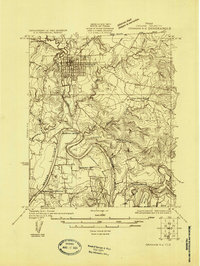 1924 Graham 4-d1924 Print · USGSYoung County in the 1920s is defined by the winding Brazos River and the growing railroad hub of Graham. Researchers can trace rural life through the locations of Flat Rock School, the Gooseneck Cem, and river crossings like the Toll Bridge.
 - 1927 Map of Graham
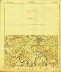 1927 Graham1927 Print · USGSYoung County's river-driven landscape comes alive in this mid-1920s survey of the Brazos River and its many bends. Genealogists can trace early rural life through Medlin Chapel, Gooseneck Cem, and several local schools like Mt Pleasant School.2 unique versions available
 - 1954 Map of Wichita Falls, 1966 Print
 1954 Wichita Falls1966 Print · USGSNorth Texas in the mid-fifties is captured here as a landscape of expanding oil fields and vital rail corridors. Genealogists and historians can trace family roots through rural landmarks like Bacon Chapel and the rail-side growth of Seymour and Archer City.3 unique versions available
 - 1958 Map of Wichita Falls
 1958 Wichita Falls1958 Print · USGSNorth Texas during the late fifties reveals a landscape defined by the booming petroleum industry and established rail hubs. Researchers can trace the development of Wichita Falls and discover rural landmarks like Barton's Chapel or the Hull-Silk Oil Field.
 - 1964 Map of Lake Eddleman, 1967 Print
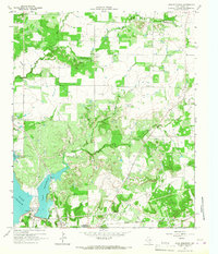 1964 Lake Eddleman1967 Print · USGSYoung County, Texas, was a landscape defined by oil production and new reservoirs in the 1960s. Genealogists and historians can trace family locations near Red Top, the Community Center Cem, and the massive Ligon Oil Field.2 unique versions available
 - 1967 Map of Graham, 1970 Print
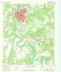 1967 Graham1970 Print · USGSGraham and the Brazos River valley in the late sixties show a landscape balancing oil production with a growing town center. Researchers can trace family roots at Oak Grove Cem or locate former crossings like Old Caseyville Crossing and Gooseneck Bridge.2 unique versions available
 - 1985 Map of Graham
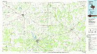 1985 Graham1985 Print · USGSNorth Texas in the mid-eighties shows a landscape of growing reservoirs and historic cattle country. Genealogists and historians can trace the foundations of Young County through the Belknap Mountains, Barton Chapel, and the grounds of Fort Richardson State Park.2 unique versions available
End of results
Showing maps 1-7 of 7
Top cities near Graham
Top neighborhoods of Graham
Frequently asked questions
- What are the different types of historical maps available for Graham?
- What is the oldest map of Graham?
- Where can I purchase historical maps of Graham for my home or office?
- Where can I download high-res historical maps of Graham?
- Are there historical topographic maps available for Graham?
- Is there historical aerial imagery available for Graham?
- Where are historical maps of Graham sourced from?