1960s Maps of Graham, Texas
Explore 2 historic maps of Graham from the 1960s. These maps offer a rare glimpse into what life looked like during the 1960s — showing old roads, neighborhoods, homes, and landmarks that have changed or disappeared over time.
Whether you're researching your family's past, planning a metal detecting trip, or studying how Graham's landscape evolved across the 1960s, these high-resolution maps are a powerful tool for exploring the history of this region.
- Focus on a specific era: All maps on this page are from the 1960s, giving you a focused view of this time period.
- See what’s changed: Compare century-old streets, trails, and buildings to today's modern landscape using overlays and satellite layers.
- Research with precision: Use these maps for genealogy, historical research, land use analysis, or educational projects.
- View, download, or print: Maps are fully viewable online in high resolution, and can be downloaded or printed for your own records.
Start exploring Graham's history through authentic maps from the 1960s. This is your window into the past.
Graham, TX maps
(2)- 1964 Map of Lake Eddleman, 1967 Print
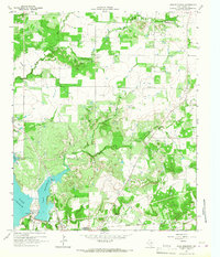 1964 Lake Eddleman1967 Print · USGSYoung County, Texas, was a landscape defined by oil production and new reservoirs in the 1960s. Genealogists and historians can trace family locations near Red Top, the Community Center Cem, and the massive Ligon Oil Field.2 unique versions available
 - 1967 Map of Graham, 1970 Print
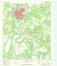 1967 Graham1970 Print · USGSGraham and the Brazos River valley in the late sixties show a landscape balancing oil production with a growing town center. Researchers can trace family roots at Oak Grove Cem or locate former crossings like Old Caseyville Crossing and Gooseneck Bridge.2 unique versions available
End of results
Showing maps 1-2 of 2
Top cities near Graham
Top neighborhoods of Graham
Frequently asked questions
- What are the different types of historical maps available for Graham?
- What is the oldest map of Graham?
- Where can I purchase historical maps of Graham for my home or office?
- Where can I download high-res historical maps of Graham?
- Are there historical topographic maps available for Graham?
- Is there historical aerial imagery available for Graham?
- Where are historical maps of Graham sourced from?