1960s Maps of Newcastle, Texas
Explore 2 historic maps of Newcastle from the 1960s. These maps offer a rare glimpse into what life looked like during the 1960s — showing old roads, neighborhoods, homes, and landmarks that have changed or disappeared over time.
Whether you're researching your family's past, planning a metal detecting trip, or studying how Newcastle's landscape evolved across the 1960s, these high-resolution maps are a powerful tool for exploring the history of this region.
- Focus on a specific era: All maps on this page are from the 1960s, giving you a focused view of this time period.
- See what’s changed: Compare century-old streets, trails, and buildings to today's modern landscape using overlays and satellite layers.
- Research with precision: Use these maps for genealogy, historical research, land use analysis, or educational projects.
- View, download, or print: Maps are fully viewable online in high resolution, and can be downloaded or printed for your own records.
Start exploring Newcastle's history through authentic maps from the 1960s. This is your window into the past.
Newcastle, TX maps
(2)- 1964 Map of Newcastle, 1967 Print
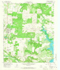 1964 Newcastle1967 Print · USGSIn the mid-1960s, the Newcastle area of Young County balanced its frontier roots with a busy coal and oil economy. Researchers can trace the legacy of the Old Military Grade or locate family sites at Belknap Cem and Wray Cem.2 unique versions available
 - 1966 Map of Proffitt, 1968 Print
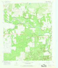 1966 Proffitt1968 Print · USGSYoung County in the mid-1960s reveals a landscape shaped by the winding Brazos River and the steady pulse of the Texas oil industry. Genealogists can locate family landmarks such as Woolfolk Cem, Proffitt Cem, and the small settlement of Proffitt.2 unique versions available
End of results
Showing maps 1-2 of 2
Top cities near Newcastle
Frequently asked questions
- What are the different types of historical maps available for Newcastle?
- What is the oldest map of Newcastle?
- Where can I purchase historical maps of Newcastle for my home or office?
- Where can I download high-res historical maps of Newcastle?
- Are there historical topographic maps available for Newcastle?
- Is there historical aerial imagery available for Newcastle?
- Where are historical maps of Newcastle sourced from?