
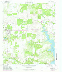
1964 Map of Newcastle
USGS Topo · Published 1967About this map
Fort Belknap State Park and the surrounding Young County landscape reveal a mid-century transition from frontier heritage to an industrial economy. The historical presence of the army post is echoed by the Old Military Grade road leading toward the town of Newcastle. By the 1960s, the local economy was clearly defined by extensive coal and petroleum extraction, evidenced by a string of workings including Belknap Mine No 2 and Belknap Mine No 4, alongside numerous Oil Wells scattered across the prairies. The Brazos River meanders along the southern border, while the eastern portion of the map is dominated by the sprawling waters of Lake Graham. Genealogists will find the Belknap Cem and Wray Cem particularly valuable for tracing local family history in this resource-rich region of North Texas.
Find a feature on this map
32 named features on this map. Tap any name to fly to it.
Don’t see what you’re looking for? This feature index may not catch every label — zoom into the map to look around manually.
Map Details
Editions of this 1964 Newcastle Map
2 editions found
Other maps of this area

1924 · Graham 4-d
USGS Topo · 1:48,000

1925 · Graham 4-c
USGS Topo · 1:48,000

1927 · Graham
USGS Topo · 1:62,500

1954 · Wichita Falls
USGS Topo · 1:250,000

1958 · Wichita Falls
USGS Topo · 1:250,000

1964 · True
USGS Topo · 1:24,000

1964 · Loving
USGS Topo · 1:24,000

1964 · Lake Eddleman
USGS Topo · 1:24,000

1964 · Olney
USGS Topo · 1:24,000
1966 · Proffitt
USGS Topo · 1:24,000