
1964 Map of Olney
USGS Topo · Published 1968About this map
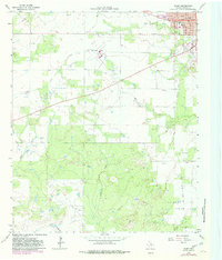
The city of Olney dominates the northeastern corner of this Young County survey, appearing as a concentrated grid of streets like Main Street, Church Street, and Pecan Street. Public life in the 1960s is anchored by institutions such as Hamilton Hospital, Griffin Park, and the High Sch. Surrounding the town center, the landscape transitions into a landscape heavily defined by petroleum extraction, with numerous Oil Wells scattered across the Larimore Oil Field and surrounding areas. This industrial presence is contrasted by the natural drainage of California Creek and Dry Creek, which meander through the southern hills toward Skid Mtn. An Old Railroad Grade runs north-south through the eastern half of the map, marking a former transportation corridor that once served the town's local economy before the dominance of the regional highway network.
Find a feature on this map
37 named features on this map. Tap any name to fly to it.
Don’t see what you’re looking for? This feature index may not catch every label — zoom into the map to look around manually.
Map Details
Editions of this 1964 Olney Map
2 editions found
Other maps of this area

1927 · Graham
USGS Topo · 1:62,500

1954 · Wichita Falls
USGS Topo · 1:250,000

1958 · Wichita Falls
USGS Topo · 1:250,000

1963 · Megargel
USGS Topo · 1:24,000

1964 · Newcastle
USGS Topo · 1:24,000

1964 · Bobcat Bluff
USGS Topo · 1:24,000

1964 · Padgett
USGS Topo · 1:24,000

1964 · True
USGS Topo · 1:24,000
1964 · Lake Olney
USGS Topo · 1:24,000
1966 · Proffitt
USGS Topo · 1:24,000