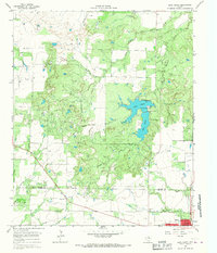
1964 Map of Lake Olney
USGS Topo · Published 1967About this map
The boundary between Archer Co and Young Co bisects a landscape defined by water management and mid-century energy production. In the southern portion of the sheet, the town of Olney is shown with its grid of streets including Main St and Gray St, serving as a hub for the surrounding countryside. This area is heavily dotted with oil wells and designated oil fields, indicating the vital role of the petroleum industry in the local economy during the 1960s.
Find a feature on this map
26 named features on this map. Tap any name to fly to it.
Don’t see what you’re looking for? This feature index may not catch every label — zoom into the map to look around manually.
Map Details
Editions of this 1964 Lake Olney Map
This is the sole edition of this map. No revisions or reprints were ever made.
Other maps of this area

1931 · Archer City
USGS Topo · 1:62,500

1932 · Dundee
USGS Topo · 1:62,500

1954 · Wichita Falls
USGS Topo · 1:250,000

1958 · Wichita Falls
USGS Topo · 1:250,000

1963 · Dundee SW
USGS Topo · 1:24,000

1963 · Megargel
USGS Topo · 1:24,000

1964 · Bobcat Bluff
USGS Topo · 1:24,000

1964 · Padgett
USGS Topo · 1:24,000

1964 · True
USGS Topo · 1:24,000

1964 · Dundee SE
USGS Topo · 1:24,000