Loading...
Loading map...1931 Map of Archer City
USGS Topo · Published 1931About this map
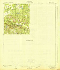
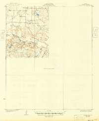
Dads Corner sits at the northern edge of this North Texas cattle and oil country, marking a landscape of wide draws and rising bluffs just before the Great Depression. This preliminary edition, surveyed in 1929 by J. A. Shumate and S. S. Evans, reveals a transition in Archer County topography where the Little Wichita River and its Middle Fk Little Wichita River begin their winding course through the eastern plains.
Find a feature on this map
7 named features on this map. Tap any name to fly to it.
Don’t see what you’re looking for? This feature index may not catch every label — zoom into the map to look around manually.
Map Details
Date Portrayed1931
Date Published1931
PublisherU.S. Geological Survey
Map TypeTopographic
Scale1:62,500
Physical Dimensions17 x 19.9 inches
Editions of this 1931 Archer City Map
2 editions found
Historical Maps of Archer City Through Time
1 maps found
Featured Locations
Source Details
SourceU.S. Geological Survey
CopyrightPublic Domain