
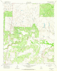
1962 Map of Windthorst
USGS Topo · Published 1964About this map
Windthorst serves as the focal point of this North Texas landscape, centered around the parish life of St Mary Ch and its adjacent St Mary Cem. The 1962 topography reveals a community structured by religious and educational centers, including the local High Sch and an Athletic Field. Beyond the town center, the land is heavily marked by the energy and ranching industries that drive the regional economy. The Antelope Oil Field and Regular Oil Field are crisscrossed by a Transcontinental Pipeline, while the Bridwell Ranch occupies the southwestern quadrant. Drainage is defined by the West Fork Little Post Oak Creek and Little Post Oak Creek, which weave through terrain also containing a Rifle Range and a small Landing Strip, indicating a mix of recreational and private aviation use during the early 1960s.
Find a feature on this map
19 named features on this map. Tap any name to fly to it.
Don’t see what you’re looking for? This feature index may not catch every label — zoom into the map to look around manually.
Map Details
Editions of this 1962 Windthorst Map
This is the sole edition of this map. No revisions or reprints were ever made.
Other maps of this area

1931 · Archer City
USGS Topo · 1:62,500

1954 · Wichita Falls
USGS Topo · 1:250,000

1958 · Wichita Falls
USGS Topo · 1:250,000

1962 · Antelope Creek NE
USGS Topo · 1:24,000

1963 · Deer Creek
USGS Topo · 1:24,000

1963 · Scotland
USGS Topo · 1:24,000
1963 · Archer City NE
USGS Topo · 1:24,000

1963 · Archer City East
USGS Topo · 1:24,000

1964 · Darnell Branch
USGS Topo · 1:24,000

1964 · Antelope
USGS Topo · 1:24,000