
1964 Map of Bobcat Bluff
USGS Topo · Published 1967About this map
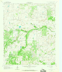
The Anarene Oil Field dominates this north-central Texas landscape, where the extraction of resources shaped the development of the Archer and Young county line. Centered on the settlement of Anarene, the map illustrates a network of petroleum infrastructure and service roads characteristic of the region's 20th-century oil boom. The terrain is defined by the drainage systems of the West Fork Trinity River and South Fork Trinity River, which converge near Thief Lakes. An Old Railroad Grade cuts diagonally across the quadrangle, marking the path of former rail commerce that once supported the local cattle and oil industries. Elevated landmarks like Bobcat Bluff offer a contrast to the river bottomlands, while scattered features such as a Gravel Pit and a Substation indicate a landscape transitioned from open ranching to industrial utility.
Find a feature on this map
17 named features on this map. Tap any name to fly to it.
Don’t see what you’re looking for? This feature index may not catch every label — zoom into the map to look around manually.
Map Details
Editions of this 1964 Bobcat Bluff Map
This is the sole edition of this map. No revisions or reprints were ever made.
Other maps of this area

1931 · Archer City
USGS Topo · 1:62,500

1932 · Dundee
USGS Topo · 1:62,500

1954 · Wichita Falls
USGS Topo · 1:250,000

1958 · Wichita Falls
USGS Topo · 1:250,000

1963 · Archer City East
USGS Topo · 1:24,000

1964 · True
USGS Topo · 1:24,000

1964 · Dundee SE
USGS Topo · 1:24,000

1964 · Loving
USGS Topo · 1:24,000

1964 · Archer City West
USGS Topo · 1:24,000
1964 · Prickly Pear Branch
USGS Topo · 1:24,000