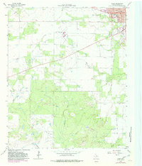
1964 Map of Olney
USGS Topo · Published 1982About this map
The town of Olney dominates the northeastern corner of this 1964 survey, revealing a post-war landscape defined by petroleum extraction and community infrastructure. Detailed street-level mapping shows the layout of Main and Oak streets, alongside essential institutions like Hamilton Hospital and the local High Sch. The surrounding terrain is a mosaic of active resource management, evidenced by numerous Oil Wells and the extensive Larimore Oil Field to the south.
Find a feature on this map
34 named features on this map. Tap any name to fly to it.
Don’t see what you’re looking for? This feature index may not catch every label — zoom into the map to look around manually.
Map Details
Editions of this 1964 Olney Map
2 editions found
Other maps of this area

1927 · Graham
USGS Topo · 1:62,500

1954 · Wichita Falls
USGS Topo · 1:250,000

1958 · Wichita Falls
USGS Topo · 1:250,000

1963 · Megargel
USGS Topo · 1:24,000

1964 · Newcastle
USGS Topo · 1:24,000

1964 · Bobcat Bluff
USGS Topo · 1:24,000

1964 · Padgett
USGS Topo · 1:24,000

1964 · True
USGS Topo · 1:24,000
1964 · Lake Olney
USGS Topo · 1:24,000

1964 · Olney
USGS Topo · 1:24,000