1990s Maps of Brigham City, Utah
Explore 7 historic maps of Brigham City from the 1990s. These maps offer a rare glimpse into what life looked like during the 1990s — showing old roads, neighborhoods, homes, and landmarks that have changed or disappeared over time.
Whether you're researching your family's past, planning a metal detecting trip, or studying how Brigham City's landscape evolved across the 1990s, these high-resolution maps are a powerful tool for exploring the history of this region.
- Focus on a specific era: All maps on this page are from the 1990s, giving you a focused view of this time period.
- See what’s changed: Compare century-old streets, trails, and buildings to today's modern landscape using overlays and satellite layers.
- Research with precision: Use these maps for genealogy, historical research, land use analysis, or educational projects.
- View, download, or print: Maps are fully viewable online in high resolution, and can be downloaded or printed for your own records.
Start exploring Brigham City's history through authentic maps from the 1990s. This is your window into the past.
Brigham City, UT maps
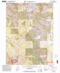
(7)- 1991 Map of Mount Pisgah
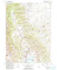 1991 Mount Pisgah1991 Print · USGSThe eastern Cache Valley and the soaring Wellsville Mountains are captured here in the early 1990s as the region balanced its agricultural roots with mountain wilderness. Genealogists and hikers can trace old landmarks like the Mount Sterling Cem, the remote Gold Mine, and the waters of the Mantua Reservoir.
 - 1991 Map of Mantua, 1992 Print
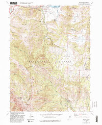 1991 Mantua1992 Print · USGSNear the high ridges of the Wasatch Range in the early 1990s, this area shows a unique blend of mountain mining and valley settlement. Researchers can trace old mountain workings like the Silver Eagle Mine or locate historical social sites including the Bel Mia Girls Home and Camp Utaba.2 unique versions available
 - 1992 Map of Willard
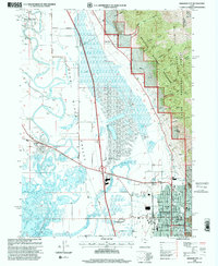
 1992 Willard1992 Print · USGSThe interface of the Wasatch Range and the Great Salt Lake is documented here in the early nineties, showing the growth of Brigham City and Willard. Researchers can trace old water rights along the Ogden Brigham Canal and find local landmarks like the Willard City Spring and Cem.
 - 1998 Map of Willard, 2001 Print
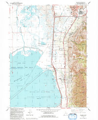
 1998 Willard2001 Print · USGSThe eastern shores of the Great Salt Lake come into focus in the late nineties, showing the interface of the Wasatch peaks and the bay. Researchers can trace the layout of Willard, locate the Cem, and explore the canyon systems of Pearsons Canyon and Matthias Canyon.
 - 1998 Map of Mantua, 2001 Print
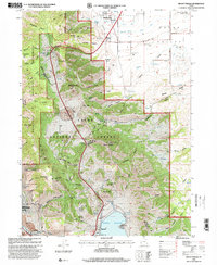
 1998 Mantua2001 Print · USGSMantua and the high ridgelines of the Wasatch Range are shown in detail during the late nineties. Local history researchers can trace old mining operations like the Holton Mine, locate the Bel Mia Girls Home, and explore the canyon lands surrounding Mantua Reservoir.
 - 1998 Map of Brigham City, 2001 Print
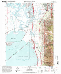
 1998 Brigham City2001 Print · USGSBrigham City and the surrounding Bear River Valley are shown here in the late nineties, balancing a growing urban center with vast wetlands. Researchers can trace family sites at Harper Ward Cemetery or locate historic landmarks like the Calls Fort Monument.
 - 1998 Map of Mount Pisgah, 2001 Print
 1998 Mount Pisgah2001 Print · USGSThe northern Wellsville Mountains and Cache Valley are captured here during the late nineties as regional development met wilderness protection. Researchers can trace historic routes like Sardine Canyon Road, locate the Mount Sterling Cem, or find industrial sites like the Silver Mine.
End of results
Showing maps 1-7 of 7
Top cities near Brigham City
- Logan historical maps
- North Ogden historical maps
- Pleasant View historical maps
- Tremonton historical maps
- Hyrum historical maps
- Farr West historical maps
See more
Frequently asked questions
- What are the different types of historical maps available for Brigham City?
- What is the oldest map of Brigham City?
- Where can I purchase historical maps of Brigham City for my home or office?
- Where can I download high-res historical maps of Brigham City?
- Are there historical topographic maps available for Brigham City?
- Is there historical aerial imagery available for Brigham City?
- Where are historical maps of Brigham City sourced from?