1980s Maps of Brigham City, Utah
Explore 5 historic maps of Brigham City from the 1980s. These maps offer a rare glimpse into what life looked like during the 1980s — showing old roads, neighborhoods, homes, and landmarks that have changed or disappeared over time.
Whether you're researching your family's past, planning a metal detecting trip, or studying how Brigham City's landscape evolved across the 1980s, these high-resolution maps are a powerful tool for exploring the history of this region.
- Focus on a specific era: All maps on this page are from the 1980s, giving you a focused view of this time period.
- See what’s changed: Compare century-old streets, trails, and buildings to today's modern landscape using overlays and satellite layers.
- Research with precision: Use these maps for genealogy, historical research, land use analysis, or educational projects.
- View, download, or print: Maps are fully viewable online in high resolution, and can be downloaded or printed for your own records.
Start exploring Brigham City's history through authentic maps from the 1980s. This is your window into the past.
Brigham City, UT maps
(5)- 1984 Map of Logan, 1985 Print
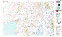
 1984 Logan1985 Print · USGSNorthern Utah and its borderlands with Idaho and Wyoming are shown here in the mid-1980s as the Cache Valley communities grew. Researchers can trace the Union Pacific rail lines and find legacy sites like College Ward, Pickleville, and Utah State University.3 unique versions available
 - 1986 Map of Ogden, 1987 Print
 1986 Ogden1987 Print · USGSThe Wasatch Front was undergoing significant development in the mid-eighties as the urban corridor stretched from Ogden toward the Great Salt Lake. Researchers can trace the legacy of regional transport and defense via Hill Air Force Base, the Union Pacific line, and mountain passes near Snow Basin.
 - 1987 Map of Promontory Point
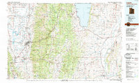
 1987 Promontory Point1987 Print · USGSThe Wasatch Front meets the great salt desert in the late eighties, showing the rapid growth of towns from Brigham City to Layton. Follow the Southern Pacific (Lucin Cutoff) across the water and explore the remote terrain of Antelope Island and Promontory Point.
 - 1988 Map of Brigham City
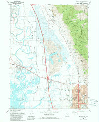 1988 Brigham City1988 Print · USGSBrigham City and the Bear River Valley are shown during the late 1980s as a bustling hub of civic life and agricultural infrastructure. Genealogists and historians can trace the street grids of Corinne, Bear River City, and Brigham City, or locate the Harper Ward Cem and the Historical Monument at Calls Fort.
 - 1989 Map of Tremonton
 1989 Tremonton1989 Print · USGSNorthern Utah and the Idaho borderlands appear here in the late eighties, centered on the historic rail corridor and the fertile Bear River valley. Genealogists and historians can trace the legacy of settlements from Washakie to Honeyville and the Golden Spike National Historic Site.2 unique versions available
End of results
Showing maps 1-5 of 5
Top cities near Brigham City
- Logan historical maps
- North Ogden historical maps
- Pleasant View historical maps
- Tremonton historical maps
- Hyrum historical maps
- Farr West historical maps
See more
Frequently asked questions
- What are the different types of historical maps available for Brigham City?
- What is the oldest map of Brigham City?
- Where can I purchase historical maps of Brigham City for my home or office?
- Where can I download high-res historical maps of Brigham City?
- Are there historical topographic maps available for Brigham City?
- Is there historical aerial imagery available for Brigham City?
- Where are historical maps of Brigham City sourced from?