1960s Maps of Newton, Utah
Explore 4 historic maps of Newton from the 1960s. These maps offer a rare glimpse into what life looked like during the 1960s — showing old roads, neighborhoods, homes, and landmarks that have changed or disappeared over time.
Whether you're researching your family's past, planning a metal detecting trip, or studying how Newton's landscape evolved across the 1960s, these high-resolution maps are a powerful tool for exploring the history of this region.
- Focus on a specific era: All maps on this page are from the 1960s, giving you a focused view of this time period.
- See what’s changed: Compare century-old streets, trails, and buildings to today's modern landscape using overlays and satellite layers.
- Research with precision: Use these maps for genealogy, historical research, land use analysis, or educational projects.
- View, download, or print: Maps are fully viewable online in high resolution, and can be downloaded or printed for your own records.
Start exploring Newton's history through authentic maps from the 1960s. This is your window into the past.
Newton, UT maps
(4)- 1960 Map of Ogden
 1960 Ogden1960 Print · USGSIn the mid-1950s, this region of the American West balanced military expansion with frontier history along the Union Pacific RR. Genealogists and historians can trace old settlements like Fort Bridger, the residential growth of Washington Terrace, and industrial sites from the Hill AFB complex to the coal mines of Kemmerer.
 - 1962 Map of Brigham City
 1962 Brigham City1962 Print · USGSNorthern Utah in the early sixties reveals a landscape of vast salt flats and growing towns along the Wasatch Front. Researchers can trace the Southern Pacific line past the Golden Spike Monument or locate landmarks like Indian Cave and Donner-Reed Pass.
 - 1964 Map of Newton, 1966 Print
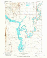 1964 Newton1966 Print · USGSNewton and the Cache Valley wetlands are captured here in the mid-1960s, showing a landscape defined by irrigation and the Union Pacific rail. Researchers can locate family sites near Benson Sch, trace the Old Railroad Grade, or find landmarks like Quigley Crossing.3 unique versions available
 - 1964 Map of Cutler Dam, 1966 Print
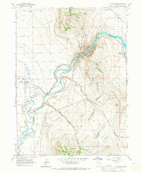 1964 Cutler Dam1966 Print · USGSThe Bear River valley in the mid-1960s shows a landscape of mountain-fringed agriculture and river engineering. Trace the historic rail and water networks connecting Fielding, Cache Junction, and the infrastructure of the Cutler Dam.
End of results
Showing maps 1-4 of 4
Top cities near Newton
- Logan historical maps
- Tremonton historical maps
- Hyrum historical maps
- North Logan historical maps
- Smithfield historical maps
- Preston historical maps
See more
Frequently asked questions
- What are the different types of historical maps available for Newton?
- What is the oldest map of Newton?
- Where can I purchase historical maps of Newton for my home or office?
- Where can I download high-res historical maps of Newton?
- Are there historical topographic maps available for Newton?
- Is there historical aerial imagery available for Newton?
- Where are historical maps of Newton sourced from?