1900s (20th Century) Maps of Moon Lake Resort, Utah
Explore 8 historic maps of Moon Lake Resort from the 1900s (20th Century). These maps offer a rare glimpse into what life looked like during the 1900s — showing old roads, neighborhoods, homes, and landmarks that have changed or disappeared over time.
Whether you're researching your family's past, planning a metal detecting trip, or studying how Moon Lake Resort's landscape evolved across the 1900s, these high-resolution maps are a powerful tool for exploring the history of this region.
- Focus on a specific era: All maps on this page are from the 1900s, giving you a focused view of this time period.
- See what’s changed: Compare century-old streets, trails, and buildings to today's modern landscape using overlays and satellite layers.
- Research with precision: Use these maps for genealogy, historical research, land use analysis, or educational projects.
- View, download, or print: Maps are fully viewable online in high resolution, and can be downloaded or printed for your own records.
Start exploring Moon Lake Resort's history through authentic maps from the 1900s. This is your window into the past.
Moon Lake Resort, UT maps
(8)- 1905 Map of Gilbert Peak, 1953 Print
 1905 Gilbert Peak1953 Print · USGSThe High Uintas at the turn of the century show a wilderness of massive peaks and early mountain ranching. Genealogists and researchers can trace the locations of isolated outposts like Smiths Ranch or Edwards Ranch and name specific summits like Mt Emmons.2 unique versions available
 - 1906 Map of Gilbert Peak
 1906 Gilbert Peak1906 Print · USGSThe high Uinta Mountains are captured in the early 1900s, showing a remote wilderness of glacial lakes and pioneer outposts. Local historians can trace early mountain life through Smiths Ranch, Gilbert Meadows, and Edwards Ranch.4 unique versions available
 - 1954 Map of Salt Lake City, 1964 Print
 1954 Salt Lake City1964 Print · USGSThe Wasatch Front and Uinta Mountains are captured here in the mid-fifties, showing the industrial heart of Utah and its high mountain wilderness. Researchers can locate vanished infrastructure and landmarks like the Geneva Steel Plant, Bingham Canyon Mine, and the Utah State Prison.4 unique versions available
 - 1958 Map of Salt Lake City
 1958 Salt Lake City1958 Print · USGSThe Wasatch Front and Uinta Basin are captured during a period of significant post-war growth and industrial development. Researchers can trace the mid-century rail lines of the Bamberger RR and locate sites like the Kiegley Limestone Quarry and Camp Williams Military Reservation.
 - 1960 Map of Salt Lake City
 1960 Salt Lake City1960 Print · USGSThe Wasatch Front and High Uintas are captured mid-century as the Salt Lake Valley underwent significant postwar expansion. Genealogists and historians can trace rail lines like the Union Pacific and locate established landmarks such as Fort Douglas, Camp Williams, and the Bingham Canyon Mine.
 - 1967 Map of Lake Fork Mtn, 1969 Print
 1967 Lake Fork Mtn1969 Print · USGSDuchesne County’s high country is captured here in the late sixties, where national forest lands meet tribal reservation boundaries. Researchers can trace the water-management history of Twin Pots Reservoir and locate family landmarks like Fisher Ranch or the Lake Fork Corral.
 - 1982 Map of Kings Peak, 1985 Print
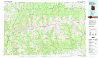 1982 Kings Peak1985 Print · USGSThe high Uinta wilderness is captured in the early eighties, showing the intersection of three national forests at the Wyoming-Utah border. Hikers and historians can trace the high trails near Kings Peak, Moon Lake, and Iron Mine Mountain.2 unique versions available
 - 1996 Map of Lake Fork Mountain, 1999 Print
 1996 Lake Fork Mountain1999 Print · USGSDuchesne County is captured here in the mid-1990s as the high wilderness meets the reservation and forest lands. Researchers can trace irrigation history through the Farnsworth Canal and find local landmarks like the Lake Fork Corral and Twin Pots Reservoir.
End of results
Showing maps 1-8 of 8
Top cities near Moon Lake Resort
Frequently asked questions
- What are the different types of historical maps available for Moon Lake Resort?
- What is the oldest map of Moon Lake Resort?
- Where can I purchase historical maps of Moon Lake Resort for my home or office?
- Where can I download high-res historical maps of Moon Lake Resort?
- Are there historical topographic maps available for Moon Lake Resort?
- Is there historical aerial imagery available for Moon Lake Resort?
- Where are historical maps of Moon Lake Resort sourced from?