1920s Maps of Orangeville, Utah
Explore 2 historic maps of Orangeville from the 1920s. These maps offer a rare glimpse into what life looked like during the 1920s — showing old roads, neighborhoods, homes, and landmarks that have changed or disappeared over time.
Whether you're researching your family's past, planning a metal detecting trip, or studying how Orangeville's landscape evolved across the 1920s, these high-resolution maps are a powerful tool for exploring the history of this region.
- Focus on a specific era: All maps on this page are from the 1920s, giving you a focused view of this time period.
- See what’s changed: Compare century-old streets, trails, and buildings to today's modern landscape using overlays and satellite layers.
- Research with precision: Use these maps for genealogy, historical research, land use analysis, or educational projects.
- View, download, or print: Maps are fully viewable online in high resolution, and can be downloaded or printed for your own records.
Start exploring Orangeville's history through authentic maps from the 1920s. This is your window into the past.
Orangeville, UT maps
(2)- 1923 Map of Castle Dale, 1958 Print
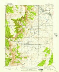 1923 Castle Dale1958 Print · USGSEmery County was a landscape of high-plateau ranching and early coal mining during the 1920s. Genealogists and researchers can trace family-named sites like the Ferron Mill, the Grillpack Mine, and Blackburns Ranch across the desert benches.3 unique versions available
 - 1925 Map of Castle Dale
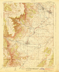 1925 Castle Dale1925 Print · USGSEmery County during the 1920s shows a landscape defined by pioneer irrigation and early coal exploration. Genealogists and local historians can locate family landmarks such as Blackburns Ranch, the Ferron Mill, and the Axel Anderson Mine.2 unique versions available
End of results
Showing maps 1-2 of 2
Top cities near Orangeville
- Huntington historical maps
- Castle Dale historical maps
- Ferron historical maps
- Cleveland historical maps
- Clawson historical maps
Frequently asked questions
- What are the different types of historical maps available for Orangeville?
- What is the oldest map of Orangeville?
- Where can I purchase historical maps of Orangeville for my home or office?
- Where can I download high-res historical maps of Orangeville?
- Are there historical topographic maps available for Orangeville?
- Is there historical aerial imagery available for Orangeville?
- Where are historical maps of Orangeville sourced from?