1970s Maps of Goshute, Utah
Explore 2 historic maps of Goshute from the 1970s. These maps offer a rare glimpse into what life looked like during the 1970s — showing old roads, neighborhoods, homes, and landmarks that have changed or disappeared over time.
Whether you're researching your family's past, planning a metal detecting trip, or studying how Goshute's landscape evolved across the 1970s, these high-resolution maps are a powerful tool for exploring the history of this region.
- Focus on a specific era: All maps on this page are from the 1970s, giving you a focused view of this time period.
- See what’s changed: Compare century-old streets, trails, and buildings to today's modern landscape using overlays and satellite layers.
- Research with precision: Use these maps for genealogy, historical research, land use analysis, or educational projects.
- View, download, or print: Maps are fully viewable online in high resolution, and can be downloaded or printed for your own records.
Start exploring Goshute's history through authentic maps from the 1970s. This is your window into the past.
Goshute, UT maps
(2)- 1972 Map of Goshute, 1975 Print
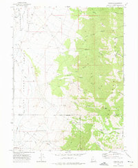 1972 Goshute1975 Print · USGSThe High Desert borderlands of Tooele and Juab counties are captured here in the early 1970s, focused on the Goshute Indian Reservation. Genealogists and researchers can trace remote landmarks like the Cem and Skinner Springs among the vast network of Jeep Trails.3 unique versions available
 - 1979 Map of Fish Springs
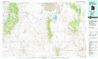 1979 Fish Springs1979 Print · USGSWestern Utah in the late seventies reveals a landscape of high peaks and desert basins, from the Deep Creek Range to the Great Salt Lake Desert. Researchers can locate remote settlements like Partoun and Callao, or trace old mining operations at the Emma Mine and Bell Hill Mine.4 unique versions available
End of results
Showing maps 1-2 of 2
Top cities near Goshute
Frequently asked questions
- What are the different types of historical maps available for Goshute?
- What is the oldest map of Goshute?
- Where can I purchase historical maps of Goshute for my home or office?
- Where can I download high-res historical maps of Goshute?
- Are there historical topographic maps available for Goshute?
- Is there historical aerial imagery available for Goshute?
- Where are historical maps of Goshute sourced from?