Old Maps of Maple Grove, Utah for Academic Research
Study the evolution of Maple Grove with 8 high-resolution historic maps. Whether you're teaching, researching, or modeling changes in land use, these maps provide essential visual documentation of urban, environmental, and geographic change.
- Analyze long-term change: Track patterns in development, transportation, and natural features.
- Ideal for environmental or urban studies: Support academic projects with primary historical map data.
- Use in the classroom or lab: Educators and researchers rely on these maps to bring historical context to life.
These maps are a powerful tool for teaching, research, and visualizing how Maple Grove has changed over the decades.
Maple Grove, UT maps
(8)- 1885 Map of Sevier Desert
 1885 Sevier Desert1885 Print · USGSMining districts and desert outposts across central Utah come to life in the mid-1880s as the railroad pushes through the canyon. Researchers can trace early industrial footprints at Silver City, locate the riverside settlement of Deseret, and follow the original Central Pacific Railroad line.5 unique versions available
 - 1953 Map of Delta, 1969 Print
 1953 Delta1969 Print · USGSWest-central Utah in the early fifties shows a landscape of vast desert playas and rising mountain ranges. Genealogists and historians can trace rail sidings like Champlin Siding, local industry at the Tungsten Mill, and historic outposts such as Fort Deseret.3 unique versions available
 - 1958 Map of Delta
 1958 Delta1958 Print · USGSThe West Desert of Utah comes into sharp focus during the late 1950s, showing the intersection of military ranges, irrigation projects, and historical transit. You can trace the proximity of the Topaz Camp to Delta, or locate the Pony Express Monument and the ruins of Fort Deseret.
 - 1962 Map of Delta
 1962 Delta1962 Print · USGSWest Central Utah in the early sixties reveals a landscape of desert agriculture and military testing grounds. Researchers can trace the Union Pacific line through Delta or locate historic sites like the Pony Express Monument and Silver City.
 - 1969 Map of Scipio Lake, 1972 Print
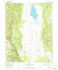 1969 Scipio Lake1972 Print · USGSThe high basins of Millard and Sanpete counties are captured in the late sixties as the ranching and timber landscape of the Pavant Range met the valley floor. Genealogists and historians can trace old pack trails, isolated Graves, and mountain camps like Maple Grove Campground.
 - 1989 Map of Delta
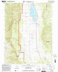
 1989 Delta1989 Print · USGSThe Millard County desert in the late eighties reveals a complex irrigation system supporting agricultural life around Delta. Researchers can trace the layout of the Union Pacific Railroad, the historic site of Topaz Camp, and the volcanic features of Pahvant Butte.2 unique versions available
 - 2001 Map of Scipio Lake, 2003 Print
 2001 Scipio Lake2003 Print · USGSMillard County at the start of the twenty-first century reveals a landscape of high-altitude canyons and vital water sources. Researchers can trace the drainage of Round Valley Creek into Scipio Lake or locate remote landmarks like Maple Grove and Dairy Knoll.
 - 2023 Map of Scipio Lake, 2023 Print
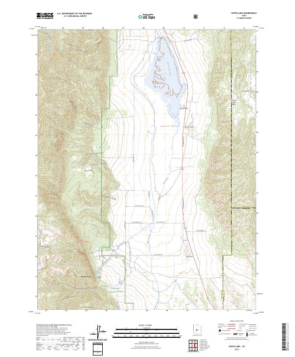 2023 Scipio Lake2023 Print · USGSMillard County's high-elevation terrain is documented here in the early twenty-first century, showing the intersection of the Pahvant and Valley ranges. Local researchers can trace old mountain routes and water sources from Scipio Lake to Maple Grove and the winding Hans Pumpernickle Canyon.
End of results
Showing maps 1-8 of 8
Top cities near Maple Grove
- Richfield historical maps
- Fillmore historical maps
- Salina historical maps
- Aurora historical maps
- Redmond historical maps
- Sigurd historical maps
See more
Frequently asked questions
- What are the different types of historical maps available for Maple Grove?
- What is the oldest map of Maple Grove?
- Where can I purchase historical maps of Maple Grove for my home or office?
- Where can I download high-res historical maps of Maple Grove?
- Are there historical topographic maps available for Maple Grove?
- Is there historical aerial imagery available for Maple Grove?
- Where are historical maps of Maple Grove sourced from?