1980s Maps of Junction, Utah
Explore 3 historic maps of Junction from the 1980s. These maps offer a rare glimpse into what life looked like during the 1980s — showing old roads, neighborhoods, homes, and landmarks that have changed or disappeared over time.
Whether you're researching your family's past, planning a metal detecting trip, or studying how Junction's landscape evolved across the 1980s, these high-resolution maps are a powerful tool for exploring the history of this region.
- Focus on a specific era: All maps on this page are from the 1980s, giving you a focused view of this time period.
- See what’s changed: Compare century-old streets, trails, and buildings to today's modern landscape using overlays and satellite layers.
- Research with precision: Use these maps for genealogy, historical research, land use analysis, or educational projects.
- View, download, or print: Maps are fully viewable online in high resolution, and can be downloaded or printed for your own records.
Start exploring Junction's history through authentic maps from the 1980s. This is your window into the past.
Junction, UT maps
(3)- 1980 Map of Beaver, 1981 Print
 1980 Beaver1981 Print · USGSSouthern Utah at the start of the 1980s reveals a rugged landscape of high mountain plateaus and essential desert irrigation networks. Researchers can trace the path of the Denver and Rio Grande Western through Marysvale or locate local landmarks like the Deer Trail Mine and Puffer Lake.2 unique versions available
 - 1981 Map of Piute Reservoir
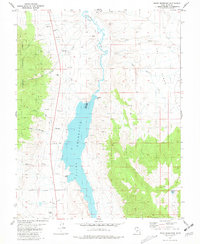 1981 Piute Reservoir1981 Print · USGSCentral Utah's water and mining history come into focus in the early 1980s. Trace local landmarks like Howes Cem, the Spillway 5971 at Piute Reservoir, and the Junction Airport near the town boundary.
 - 1981 Map of Delano Peak
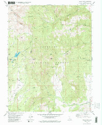 1981 Delano Peak1981 Print · USGSThe high Tushar Mountains of Piute and Beaver counties are shown in detail during the early eighties. Researchers can trace alpine mining history near Alunite Ridge, locate remote water features like Blainies Dam, and follow the old Pack Trails around Delano Peak.2 unique versions available
End of results
Showing maps 1-3 of 3
Top cities near Junction
- Circleville historical maps
- Marysvale historical maps
- Kingston historical maps
- Antimony historical maps
Frequently asked questions
- What are the different types of historical maps available for Junction?
- What is the oldest map of Junction?
- Where can I purchase historical maps of Junction for my home or office?
- Where can I download high-res historical maps of Junction?
- Are there historical topographic maps available for Junction?
- Is there historical aerial imagery available for Junction?
- Where are historical maps of Junction sourced from?