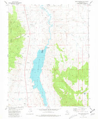
1981 Map of Piute Reservoir
USGS Topo · Published 1981About this map
Piute Reservoir dominates this central Utah landscape, with the Spillway 5971 controlling the waters at the northern end of the basin. The Sevier River flows northward from the reservoir through a valley marked by local agricultural and burial sites like Howes Cem. To the west, the foothills of the Fishlake National Forest rise sharply, characterized by drainage systems such as Gold Gulch and Tenmile Creek. The area’s resource history is evident in numerous Mine and Gravel Pit workings scattered along the canyon edges. On the southern edge, the map records the Corporate Boundary of Junction, near the Junction Airport and another small Cem. The rugged eastern terrain is defined by The Elbow and the meandering path of Swift Spring Creek, showcasing the transition from irrigated valley floors to high mountain draws.
Find a feature on this map
27 named features on this map. Tap any name to fly to it.
Don’t see what you’re looking for? This feature index may not catch every label — zoom into the map to look around manually.
Map Details
Editions of this 1981 Piute Reservoir Map
This is the sole edition of this map. No revisions or reprints were ever made.
Other maps of this area

1885 · Beaver
USGS Topo · 1:250,000

1937 · Delano Peak
USGS Topo · 1:48,000

1943 · Delano Peak
USGS Topo · 1:62,500

1945 · Marysvale
USGS Topo · 1:62,500

1947 · Marysvale
USGS Topo · 1:62,500

1953 · Richfield
USGS Topo · 1:250,000

1958 · Richfield
USGS Topo · 1:250,000

1966 · Circleville
USGS Topo · 1:24,000
1966 · Junction
USGS Topo · 1:24,000
1971 · Phonolite Hill
USGS Topo · 1:24,000