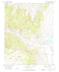
1971 Map of Phonolite Hill
USGS Topo · Published 1974About this map
Forshea Mountain and the high plateaus of south-central Utah dominate this 1971 landscape at the boundary of Piute and Garfield counties. The terrain is defined by complex drainage systems such as East Kingston Fork and Coates Hollow, which feed into the Sevier River. Evidence of land use and early resource management is clear through numerous named springs like McCardy Spring and Dripping Spring, alongside the presence of the East Fork Canal near Otter Creek Reservoir.
Find a feature on this map
48 named features on this map. Tap any name to fly to it.
Don’t see what you’re looking for? This feature index may not catch every label — zoom into the map to look around manually.
Map Details
Editions of this 1971 Phonolite Hill Map
This is the sole edition of this map. No revisions or reprints were ever made.
Other maps of this area

1885 · Beaver
USGS Topo · 1:250,000

1885 · Fish Lake
USGS Topo · 1:250,000

1896 · Fish Lake
USGS Topo · 1:250,000

1945 · Marysvale
USGS Topo · 1:62,500

1947 · Marysvale
USGS Topo · 1:62,500

1953 · Richfield
USGS Topo · 1:250,000

1956 · Salina
USGS Topo · 1:250,000

1958 · Richfield
USGS Topo · 1:250,000

1960 · Salina
USGS Topo · 1:250,000

1962 · Salina
USGS Topo · 1:250,000