1980s Maps of Marysvale, Utah
Explore 3 historic maps of Marysvale from the 1980s. These maps offer a rare glimpse into what life looked like during the 1980s — showing old roads, neighborhoods, homes, and landmarks that have changed or disappeared over time.
Whether you're researching your family's past, planning a metal detecting trip, or studying how Marysvale's landscape evolved across the 1980s, these high-resolution maps are a powerful tool for exploring the history of this region.
- Focus on a specific era: All maps on this page are from the 1980s, giving you a focused view of this time period.
- See what’s changed: Compare century-old streets, trails, and buildings to today's modern landscape using overlays and satellite layers.
- Research with precision: Use these maps for genealogy, historical research, land use analysis, or educational projects.
- View, download, or print: Maps are fully viewable online in high resolution, and can be downloaded or printed for your own records.
Start exploring Marysvale's history through authentic maps from the 1980s. This is your window into the past.
Marysvale, UT maps
(3)- 1980 Map of Beaver, 1981 Print
 1980 Beaver1981 Print · USGSSouthern Utah at the start of the 1980s reveals a rugged landscape of high mountain plateaus and essential desert irrigation networks. Researchers can trace the path of the Denver and Rio Grande Western through Marysvale or locate local landmarks like the Deer Trail Mine and Puffer Lake.2 unique versions available
 - 1980 Map of Mount Brigham, 1981 Print
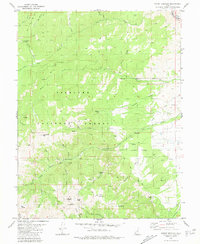 1980 Mount Brigham1981 Print · USGSThe Tushar Mountains of central Utah are captured in the early 1980s, documenting a high-country landscape of mining claims and rugged peaks. Researchers can locate specific operations like the Silver King Mine, trace the D & R G W railroad, or find landmarks like Bullion Falls.2 unique versions available
 - 1981 Map of Marysvale
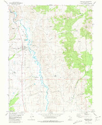 1981 Marysvale1981 Print · USGSMarysvale and the Sevier River valley in the early 1980s show a landscape shaped by mining, rail, and community life. Genealogists can locate several local burial grounds including Mountain View Cem and Murrays Cem, while historians can trace the Denver and Rio Grande Western line.
End of results
Showing maps 1-3 of 3
Top cities near Marysvale
Top neighborhoods of Marysvale
Frequently asked questions
- What are the different types of historical maps available for Marysvale?
- What is the oldest map of Marysvale?
- Where can I purchase historical maps of Marysvale for my home or office?
- Where can I download high-res historical maps of Marysvale?
- Are there historical topographic maps available for Marysvale?
- Is there historical aerial imagery available for Marysvale?
- Where are historical maps of Marysvale sourced from?