1990s Maps of Salt Lake County, Utah
Explore 26 historic maps of Salt Lake County from the 1990s. These maps offer a rare glimpse into what life looked like during the 1990s — showing old roads, neighborhoods, homes, and landmarks that have changed or disappeared over time.
Whether you're researching your family's past, planning a metal detecting trip, or studying how Salt Lake County's landscape evolved across the 1990s, these high-resolution maps are a powerful tool for exploring the history of this region.
- Focus on a specific era: All maps on this page are from the 1990s, giving you a focused view of this time period.
- See what’s changed: Compare century-old streets, trails, and buildings to today's modern landscape using overlays and satellite layers.
- Research with precision: Use these maps for genealogy, historical research, land use analysis, or educational projects.
- View, download, or print: Maps are fully viewable online in high resolution, and can be downloaded or printed for your own records.
Start exploring Salt Lake County's history through authentic maps from the 1990s. This is your window into the past.
Salt Lake County, UT maps
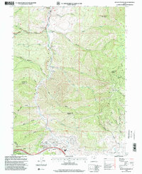
(26)- 1993 Map of Lowe Peak
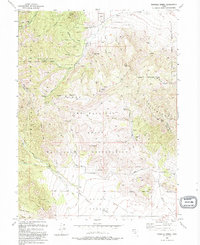
 1993 Lowe Peak1993 Print · USGSThe Oquirrh Mountains at the end of the twentieth century reveal a terrain shaped by mining and high-altitude geography. Genealogists and historians can trace old resource leads at the Queen Mine Prospects, locate the settlement of Ophir, and follow rugged trails through Piney Pass.
 - 1993 Map of Jordan Narrows
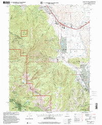
 1993 Jordan Narrows1993 Print · USGSSalt Lake County in the early 1990s shows a unique convergence of heavy infrastructure and frontier history near the Jordan Narrows. Researchers can locate the Rockwell Station Pony Express Historical Marker, the Camp Williams grounds, and the Bluffdale Cemetery.
 - 1993 Map of Tickville Spring
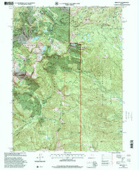
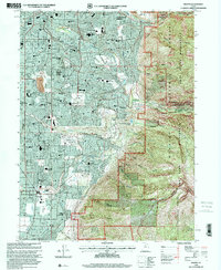
 1993 Tickville Spring1993 Print · USGSThe Oquirrh and Traverse Mountains meet in the 1990s at the Camp Williams State Military Reservation. Researchers can trace old mining prospects, the Butterfield Tunnel, and county lines near Tickville Spring and Step Mtn.2 unique versions available
 - 1994 Map of Lehi
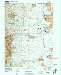
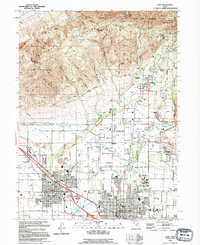 1994 Lehi1994 Print · USGSIn the mid-1990s, the northern Utah Valley was a landscape of expanding towns and complex irrigation. Genealogists and local historians can trace the foundations of Lehi and Alpine, locating landmarks like Lehi Cem and the Utah State Training School.
 - 1997 Map of Saltair NE, 2001 Print
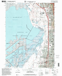
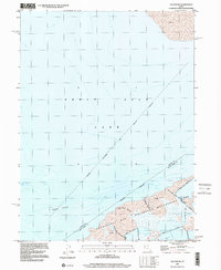 1997 Saltair NE2001 Print · USGSThe Davis County shoreline and Great Salt Lake transition zone are captured here in the late nineties, showcasing the region's managed wetlands. Environmental researchers and local historians can trace the paths of Crystal Creek and the Salt Lake City Sewage Canal through the Waterfowl Management Area.
 - 1997 Map of Tickville Spring, 2001 Print
 1997 Tickville Spring2001 Print · USGSThe foothills of the Oquirrh Mountains meet the military landscape of the late nineties, showing the transition from public parks to restricted ranges. Trace the boundaries of Camp Williams and locate family landmarks like Tickville Spring and Shaggy Peak.
 - 1997 Map of Baileys Lake, 2001 Print
 1997 Baileys Lake2001 Print · USGSThe wetlands of the Great Salt Lake are captured here in the late nineties, showing a landscape of hunting clubs and water management. Trace the Old Railroad Grade and find historic sites like Riter and the Harrison Duck Club.
 - 1997 Map of Lowe Peak, 2002 Print
 1997 Lowe Peak2002 Print · USGSThe Oquirrh Mountains at the turn of the millennium reveal a landscape of high summits and historical mining activity. Researchers can trace remote Pack Trails and locate evidence of past industry at Mine Ruins and Lowe Basin.
 - 1997 Map of Bingham Canyon, 2002 Print
 1997 Bingham Canyon2002 Print · USGSThe Oquirrh Mountains in the late twentieth century reveal the intersection of high-altitude peaks and massive mining industrialization. Researchers can trace the sprawling Copper Pit Mine, the settlement of International, and industrial relics like the Tramway (Abandoned).
 - 1998 Map of Lehi, 2000 Print
 1998 Lehi2000 Print · USGSNorthern Utah Valley undergoes a period of rapid suburban growth in the late nineties as residential borders expand toward the mountains. Genealogists and local historians can trace family plots in the Lehi Cem or locate community hubs like Sego Lily Sch and the Utah State Developmental Center.
 - 1998 Map of Big Dutch Hollow, 2000 Print
 1998 Big Dutch Hollow2000 Print · USGSThe Mormon migration and Pony Express trails meet modern developments in these Utah mountains during the late nineties. Trace the Mormon Pioneers Route past Mormon Flat and the historic Macfarlane Ranch.
 - 1998 Map of Farmington, 2001 Print
 1998 Farmington2001 Print · USGSThe eastern shore of the Great Salt Lake comes into focus in the late nineties as suburban growth reaches the mountain foothills. Genealogists and local historians can trace the development of Farmington, Lagoon, and schools like Reading Sch and Stewart Sch.
 - 1998 Map of Salt Lake City North, 2001 Print
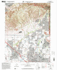
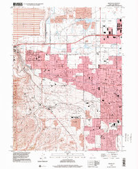
 1998 Salt Lake City North2001 Print · USGSSalt Lake City and its northern neighbors appear at the end of the century as the region prepared for the 2002 Winter Olympics. Researchers can trace the massive industrial and transport hubs near Skypark Airport or locate civic landmarks like the State Capitol and the historic Pony Exp Mon.
 - 1998 Map of Brighton, 2001 Print
 1998 Brighton2001 Print · USGSThe high Wasatch Range in the late nineties shows the convergence of alpine recreation and historic silver mining. Trace the shafts of the Daly West Mine and Flagstaff Mine or locate the Silver Lake Info and Rec Area at Brighton.
 - 1998 Map of Mountain Dell, 2001 Print
 1998 Mountain Dell2001 Print · USGSThe high passes and historic migration trails east of Salt Lake City are preserved here in the late nineties. Trace the footsteps of the Mormon Pioneers and locate landmark markers like the Ephraim Hanks Station Pony Express Marker or the Camp Grant Hist Site.
 - 1998 Map of Fort Douglas, 2001 Print
 1998 Fort Douglas2001 Print · USGSThe eastern edges of Salt Lake City and Bountiful meet the high Wasatch front in the late nineties, just as the region prepared for the Winter Olympics. Researchers can trace the boundaries of Fort Douglas, find the City Cemetery, and see the footprint of the Olympic Village.
 - 1998 Map of Park City West, 2001 Print
 1998 Park City West2001 Print · USGSThe Park City area was undergoing a massive transformation in the late nineties as it prepared for the winter games. Local historians and genealogists can trace the shift from mining to tourism through landmarks like the Silver King Mine, Snyderville, and the City Cem.
 - 1998 Map of Sugar House, 2001 Print
 1998 Sugar House2001 Print · USGSSalt Lake City and Murray expand toward the Wasatch Front in the late nineties as the suburban grid meets the wilderness. Trace local heritage at Wheeler Historic Farm, the Sugar House Monument, or find family records at Elysian Burial Gardens and Knudsens Corner.
 - 1998 Map of Mount Aire, 2001 Print
 1998 Mount Aire2001 Print · USGSThe high Wasatch canyons come into focus in the late nineties, documenting a landscape of rugged summits and seasonal retreats. Locate historical workings like the Maxfield Mine, or trace the summer residents at Mill D Summer Home Area.
 - 1998 Map of Dromedary Peak, 2001 Print
 1998 Dromedary Peak2001 Print · USGSThe high Wasatch Range at the close of the twentieth century reveals a rugged intersection of heavy mining history and mountain recreation. Local researchers can trace old tunnel systems and claims like the Wasatch Mine, Cardiff Mine, and the historic settlement at Alta.
 - 1998 Map of Draper, 2001 Print
 1998 Draper2001 Print · USGSSandy City and Draper are shown during a period of rapid suburban expansion in the late nineties, right up to the edge of the wilderness. Researchers can trace the development of local neighborhoods alongside landmarks like Union Cem, Granite, and Mellen Sand Spur.
 - 1999 Map of Salt Lake City South, 2001 Print
 1999 Salt Lake City South2001 Print · USGSSalt Lake Valley settlement reached a peak of suburban development by the late nineties, filling the space between the river and the western benches. Researchers can trace the evolution of neighborhoods like Taylorsville and Kearns, or locate landmarks such as Franklin Covey Field and Redwood Mem Estates.
 - 1999 Map of Copperton, 2001 Print
 1999 Copperton2001 Print · USGSThe southwestern Salt Lake Valley was rapidly suburbanizing at the end of the century, even as the massive copper operations remained active. Genealogists and local historians can trace the early footprints of Herriman and Copperton, locating sites like the Bingham City Cem and Fort Herriman Historical Marker.
 - 1999 Map of Magna, 2001 Print
 1999 Magna2001 Print · USGSThe Salt Lake Valley at the end of the century shows a unique blend of heavy industry and suburban growth. Trace family roots at Pleasant Green Cem or find local landmarks like the Magna Mill and the Utah Olympic Oval.
 - 1999 Map of Jordan Narrows, 2001 Print
 1999 Jordan Narrows2001 Print · USGSThe Jordan Narrows area at the turn of the millennium shows a landscape defined by military training and massive water infrastructure. Trace local history at the Bluffdale City Cemetery or follow the Old Railroad Grade near Camp Williams.
Showing maps 1-25 of 26
Top cities of Salt Lake County
- Salt Lake City historical maps
- West Valley City historical maps
- West Jordan historical maps
- Sandy historical maps
- South Jordan historical maps
- Millcreek historical maps
See more
Frequently asked questions
- What are the different types of historical maps available for Salt Lake County?
- What is the oldest map of Salt Lake County?
- Where can I purchase historical maps of Salt Lake County for my home or office?
- Where can I download high-res historical maps of Salt Lake County?
- Are there historical topographic maps available for Salt Lake County?
- Is there historical aerial imagery available for Salt Lake County?
- Where are historical maps of Salt Lake County sourced from?