1960s Maps of Salt Lake County, Utah
Explore 11 historic maps of Salt Lake County from the 1960s. These maps offer a rare glimpse into what life looked like during the 1960s — showing old roads, neighborhoods, homes, and landmarks that have changed or disappeared over time.
Whether you're researching your family's past, planning a metal detecting trip, or studying how Salt Lake County's landscape evolved across the 1960s, these high-resolution maps are a powerful tool for exploring the history of this region.
- Focus on a specific era: All maps on this page are from the 1960s, giving you a focused view of this time period.
- See what’s changed: Compare century-old streets, trails, and buildings to today's modern landscape using overlays and satellite layers.
- Research with precision: Use these maps for genealogy, historical research, land use analysis, or educational projects.
- View, download, or print: Maps are fully viewable online in high resolution, and can be downloaded or printed for your own records.
Start exploring Salt Lake County's history through authentic maps from the 1960s. This is your window into the past.
Salt Lake County, UT maps
(11)- 1960 Map of Salt Lake City
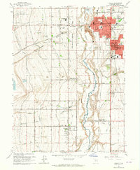
 1960 Salt Lake City1960 Print · USGSThe Wasatch Front and High Uintas are captured mid-century as the Salt Lake Valley underwent significant postwar expansion. Genealogists and historians can trace rail lines like the Union Pacific and locate established landmarks such as Fort Douglas, Camp Williams, and the Bingham Canyon Mine.
 - 1961 Map of Big Dutch Hollow, 1963 Print
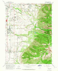
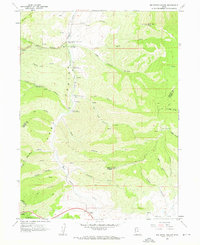 1961 Big Dutch Hollow1963 Print · USGSThe Wasatch Range in the early 1960s reveals the deep history of western expansion along the Donner-Reed Party trail. Genealogists and historians can trace the paths of early travelers through Little Emigration Canyon and locate Historic Ruins or the Mormon Flat Historical Marker.3 unique versions available
 - 1961 Map of Mountain Dell, 1963 Print
 1961 Mountain Dell1963 Print · USGSThe high Wasatch ridges east of Salt Lake City are captured here in the early 1960s, showing a landscape defined by pioneer history and modern utility. Trace the Route of Donner-Reed Party and the Mormon Trail near monuments like Last Camp.4 unique versions available
 - 1963 Map of Fort Douglas, 1964 Print
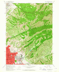 1963 Fort Douglas1964 Print · USGSSalt Lake City and the Wasatch foothills meet in the early sixties, as the city pushes eastward against the national forest. Genealogists and local historians can trace the grounds of Fort Douglas, the City Cemetery, and landmarks like the This is the Place Monument.5 unique versions available
 - 1963 Map of Sugar House, 1964 Print
 1963 Sugar House1964 Print · USGSThe southeastern valley of Salt Lake City is shown during its mid-century growth phase as suburban neighborhoods reached the mountain base. Genealogists and historians can trace family locations near Knudsens Corner, Westminster College, or the Elysian Burial Gardens.3 unique versions available
 - 1963 Map of Midvale, 1964 Print
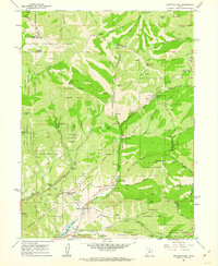
 1963 Midvale1964 Print · USGSThe Salt Lake Valley undergoes a mid-century transformation as suburban growth reaches into agricultural corridors along the Jordan River. Genealogists and historians can trace family plots at Wite Fort Cem or study the industrial rail infrastructure serving the Sugar Refinery.3 unique versions available
 - 1963 Map of Draper, 1964 Print
 1963 Draper1964 Print · USGSThe Salt Lake Valley undergoes rapid change in the early sixties as residential growth reaches toward the Wasatch range. Genealogists and historians can trace family locations near Draper and Butlerville, or locate the Temple Granite Quarry and early airfields like Alta Airpark.3 unique versions available
 - 1963 Map of Salt Lake City South, 1965 Print
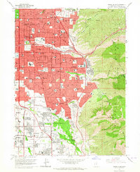
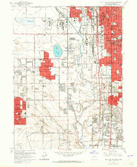 1963 Salt Lake City South1965 Print · USGSThe Salt Lake Valley in the early sixties shows the rapid expansion of suburbs like Kearns and Granger along the Jordan River. Genealogists and historians can trace numerous neighborhood landmarks, including Redwood Memorial Estates and the Utah Central Airport.4 unique versions available
 - 1963 Map of Salt Lake City North, 1965 Print
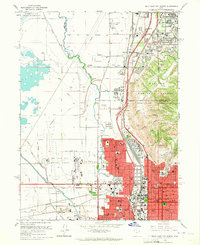 1963 Salt Lake City North1965 Print · USGSSalt Lake City and its northern neighbors appear in the early sixties during a peak era of aviation and industrial expansion. Genealogists and local historians can trace the development of Rose Park, locate the Pony Express Monument, or find neighborhood schools like Backman Sch.6 unique versions available
 - 1968 Map of Lowe Peak, 1971 Print
 1968 Lowe Peak1971 Print · USGSThe Oquirrh Mountains at the end of the sixties reveal a landscape defined by military boundaries and mining history. Trace the high-altitude Old Military Road or locate historical extraction sites like the Old Mayflower Mine and Queen Mine.
 - 1968 Map of Plug Peak SE, 1972 Print
 1968 Plug Peak SE1972 Print · USGSThe northern reaches of the Great Salt Lake are captured here in the late sixties, showing the water levels at a specific historical moment. Researchers can trace the tri-county meeting point and locate a prominent Mud Flat along the shore.
End of results
Showing maps 1-11 of 11
Top cities of Salt Lake County
- Salt Lake City historical maps
- West Valley City historical maps
- West Jordan historical maps
- Sandy historical maps
- South Jordan historical maps
- Millcreek historical maps
See more
Frequently asked questions
- What are the different types of historical maps available for Salt Lake County?
- What is the oldest map of Salt Lake County?
- Where can I purchase historical maps of Salt Lake County for my home or office?
- Where can I download high-res historical maps of Salt Lake County?
- Are there historical topographic maps available for Salt Lake County?
- Is there historical aerial imagery available for Salt Lake County?
- Where are historical maps of Salt Lake County sourced from?